 |
| Guadalupe Peak, the highest in Texas |
by
Andrew Stuart
Editor, Hudspeth County Herald and Dell Valley Review
Texas Mountain Trail Board Member
Editor, Hudspeth County Herald and Dell Valley Review
Texas Mountain Trail Board Member

The
trail passes from the grassy foothills of the eastern slopes to the stony
defiles below Capitan's tower, to the crest of the Salt Basin Overlook, at the
southern foot of El Capitan; from the overlook, the trail winds through sharp
and exposed terrain along the western face of the mountains, above vertiginous
heights and below the 2,000-foot cliffs of the escarpment, to the head of
Shumard Canyon. The path then drops down through the canyon's gorge to the
historic Williams Ranch House, built in 1908. On the return, the Salt Basin
Overlook Trail winds along the ledge below El Capitan, through a wonderland of
boulders. The trails can be taken as a shorter, 11.5-mile day hike, excluding
the leg from Shumard Canyon and back.
I carried, among other things, a sleeping bag, a tent, a light-weight camping
stove, some dishware and two gallons of water. A package of powdered,
just-add-water food. Early in the hike, feeling the weight of the water on my
back, it occurred to me it would be nice if someone would invent powdered
water. I guess, you know, you'd just add water.
 |
| View from the east |
Around
the base of El Capitan, coming to the Salt Basin Overlook, and a sudden view of
much of Hudspeth County: the Patterson Hills, the flats and dunes, Round
Mountain – a little blemish on the flats, casting a tiny shadow; the Cornudas –
San Antonio, Chatfield, Wind mountains, Cerro Alto in the far distance, at the
El Paso County line; and, hazy in the southwest, Sierra Blanca, Little Blanca
and Round Top mountains.
I
spent a day and a half out in the wilderness, in the park, I sweated and
labored around boulder and cliff, with the broken rocks below and before me,
over pass and then pass again, circling, twisting about the colossus of El
Capitan. Oh, I sweated and labored, at home Sunday evening my shirt collar is
starched and blackened with sweat and dirt. I sweated and labored, and,
37-year-old that I am, no spring chicken, at one, or two, moments, I despaired:
on a gray helmet of rock, a beautiful place, overlooking the chasm of Shumard
Canyon, I saw the trail's end far below me – 1,000, 1,200 feet? – and balked at
the thought of having to retrace my path, back up the canyon, the next morning.
And again in the shaded slopes, the lea of the El Capitan Trail, on my return
journey, just past the junction of the Salt Basin Overlook trail, at the foot
my last serious climb. Now those points seem dear to me, especially the second,
the cool, blue place, where I thought perhaps I should just lay down and die.
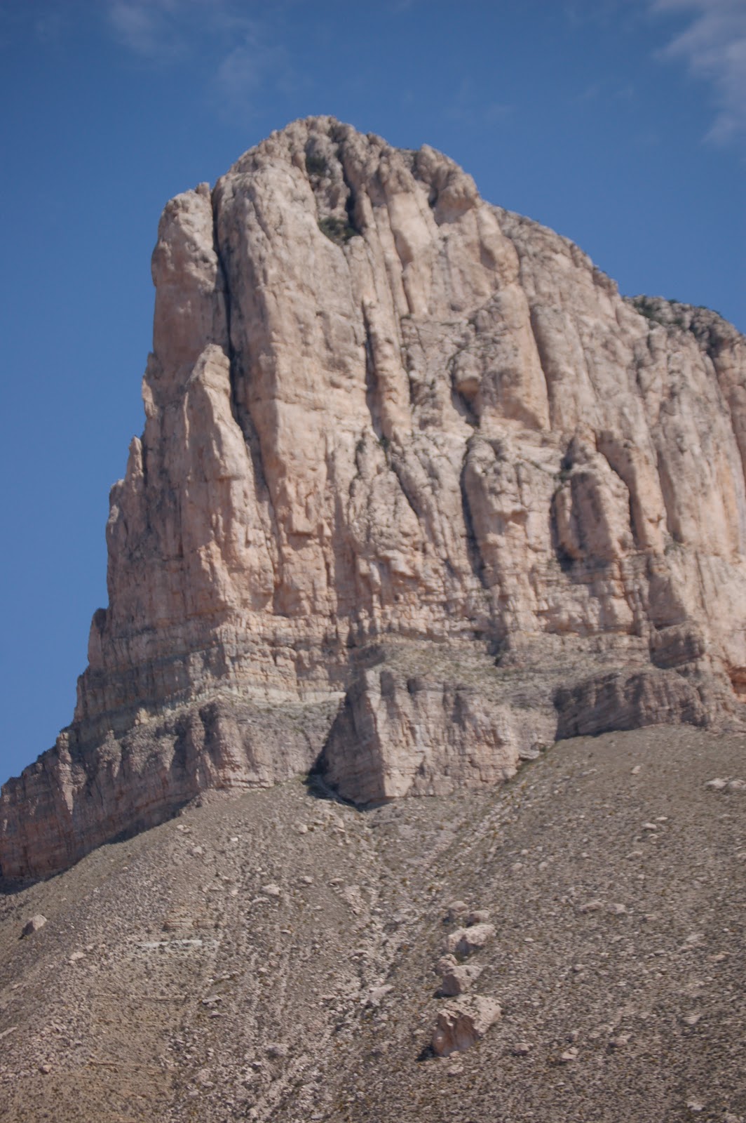
From
the park's information:
“The
most striking feature of GuadalupeMountains National Park is the thousand-foot high El Capitan, which
can be seen from miles around. Early settlers used it as a landmark on the
route through Guadalupe Pass.
El Capitan is composed of Capitan Limestone, which is the
Permian-aged limestone reef deposit. A reef is a submerged resistant mound or
ridge formed by the accumulation of plant and animal skeletons. The Capitan
Limestone is a massive, fine-grained fossiliferous limestone that formed by
growth and accumulation of invertebrate skeleton of algae, sponges, and tiny
colonial animals called bryozoans. These skeletons were stabilized by
encrusting organisms that grew over and cemented the solid reef rock, unlike
modern reefs built by mainly a rigid framework of corals.
Below this massive cliff of Capitan Limestone you can see
a prominent sandstone ledge of the Brushy Canyon sandstone which formed when
the off-shore basin began to slowly subside.
 |
| View from the West |
Because of the Capitan's greater resistance to erosion, it
forms this cliff which looms majestically above the horizon for us all to see.”
I
steered myself by that colossus. I gloried in it, at the overlook, its full
sentinel form above, wind sweeping east on the outward journey and west on the
return, or I despaired, when it was high above, above slopes strewn with
boulders, giant stones, from the age of titans. From the low points, the burned
desert, then again up, to within one mad scramble to the foot of the
escarpment. The honey-colored heights of the escarpment in mid-morning. I
walked across the charred ground where the El Capitan Fire burned, in May, and
saw the folds and that bare face of the mountain, which my neighbor and myself
see each day. I saw its dark places, its intimate folds. I cannot report, or I
can only report a part, of what I saw – its ugly secrets and its satin slipper,
its golden slumber.
The Salt Basin trail is part of the Peak Fitness Challenge, a project of the Texas Mountain Trail, GeoBetty, Guadalupe Mountains National Park and Franklin Mountains State Park. Here's the Challenge's page for the trail....join the Challenge today!
No comments:
Post a Comment