Thursday, March 07, 2013

Be a part of El Paso History!

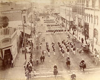
Parade in downtown El Paso, circa 1890s
photo from El Paso County Historical Society


Event: El Paso History Summit.
When: March 16, 2013
Time: Noon to 6 p.m.
Where: 1340 Murchison

This free event is open to the public and is hosted by the El Paso History Radio Show, El Paso County Historical Commission, El Paso Mission Trail Association, and El Camino Real de Tierra Adentro Trail Association (CARTA). The El Paso History Summit is an opportunity for El Pasoans to help define what El Paso history is and how it should be preserved. Event organizers will use participants’ feedback to better promote heritage tourism for the Paso del Norte region.
Bring up to 10 photos that are at least 25 years old and have all persons identified, if possible, as well as the date and place. Photos are to be scanned onsite and returned back to the owners. The goal is to include all these photos on the interactive Digital Wall that will be installed at the El Paso Museum of History.

The summit will also kick off the “I Am El Paso” campaign, where the public can video record a 1-2 minute message that identifies themselves to the El Paso area. There will be a Town Hall meeting on El Paso history with special invited guests state Senator Jose Rodriguez and El Paso County Historical Commission chairman, Bernie Sargent. The Town Hall will be moderated by hosts of "The El Paso History Radio Show," Jackson Polk and Melissa Sargent.

Other events include screenings of local documentaries, such as, “El Paso’s Mission Trails” and the world premiere of segments from Capstone Productions’ latest documentary, "The Last Tour of theEl Paso Smelter." After three years of filming the demolition of the former Asarco site, the first installment of the El Paso Smelter documentary series covers the history and construction of one of the world’s tallest smokestacks.

Be a part of the first El Paso History Summit by sharing your history of El Paso with the community and help promote our diverse cultural identity. There will also be giveaways and other door prizes throughout the day.

Wednesday, March 06, 2013

What IS the Texas Mountain Trail?

Our organization, the non-profit Texas Mountain Trail, began with the roadsigns along a figure-8 in Far West Texas.  The scenic driving route was set up in the mid-sixties by Governor Connolly's effort to promote ALL of Texas for HemisFair '68.  Not only was there a Texas Mountain Trail in Far West Texas, but there were nine other scenic driving routes all across Texas, each designed to show the best of a particular region.

Fast forward to the 1990s, and the state's effort to promote visitation to our historic sites and to encourage travelers to find "the authentic Texas."  The legislature empowered the Texas Historical Commission to develop--through a blend of federal/state/local funds--the Texas Heritage Trails program.  The first region to be developed was the Abilene-based Texas Forts Trail.  Our Texas Mountain Trail organization kicked off in 2005.

Since then we've been promoting the assets of Far West Texas to travelers (and in turn, helping with the economic development of the region) and developing programs like:

Far West Texas Wildlife Trail Sign
Barton Warnock Center
Big Bend Ranch State Park
The Far West Texas Wildlife Trail (in partnership with Texas Parks and Wildlife and our neighboring Texas Pecos Trail)


Peak Fitness Challenge website
www.geobetty.com/peak
The Peak Fitness Challenge (in partnership with PhiDev, Inc., GeoBetty.com, Guadalupe Mountains National Park and Franklin Mountains State Park)

Easy avenues for you to discover your own Texas Mountain Adventure, through our Facebook page, our Twitter account, our YouTube Channel, as well as our appearance at many marathon and bike event expos and speaking engagements at places around the state including an REI store near you!

We are working on special projects JUST FOR YOU, including researching heritage foodways, Dining Along Historic Highways, the CCC in the region, and the craft of bootmaking.

And we're providing technical and marketing support for individuals and businesses that are supporting the economies of our Far West Texas communities.  Won't you join us?

BECOME A MEMBER:
 
Now you can join Texas Mountain Trail as a member, and help support the growth of the region.
 
Click here to make a safe, secure tax-deductible membership donation!   (Membership gifts are tax-deductible to the extent allowed by law, contact your tax advisor for questions)

Tuesday, March 05, 2013

Take a break from fast food: Visit Papa's Pantry in Van Horn

There's a family-owned place to stop to eat on I-10 that folks may not know about...Papa's Pantry in Van Horn.  Take the second exit in Van Horn and head just south of the interstate.
Inside, you'll find locals dining on some of the best Mexican food around.  If you get a sandwich, it will be served on homemade bread! 

BECOME A MEMBER!

Now you can join our organization and help us help YOU find the best places in Far West Texas! 

Click HERE to learn more! It is fast, safe and secure.

Monday, March 04, 2013

Spring Break at Fort Davis National Historic Site


Every day during Spring Break, March 9-16, there will be living history soldiers and ladies present to add to your visit and illuminate the history of Fort Davis National Historic Site.  The site will be open from 8-5 and there will be programs twice a day at 10:30 and 2 on various topics, including Baseball in the 1880s, a Parasol Walk of Officers Row,  Army Medicine and more! 

Visit the Fort and have a great time!


Sunday, March 03, 2013

Poppies Fest!

Make plans to attend the Poppies Fest, Sat. March 23, 10 am to 4 pm at the El Paso Museum of Archaeology, Free Parking and Free Shuttle at EPCC NE Campus off Gateway North - NO parking at the museum. Enjoy live music & dance, art & food vendors, children's activity center, live wolf and hawk, nature tours & talks

Saturday, March 02, 2013

Early life in Culberson County


In the collection of the Clark Hotel Museum, is a wonderful photo archive, digitally preserved by the Portal to Texas History at UNT Libraries.  Our Texas Mountain Trail non-profit organization was happy to assist the museum with their digitization project several years ago, as a service to the Town of Van Horn.

You can see the entire collection here--http://texashistory.unt.edu/explore/partners/CHM/browse/.  Have fun browsing!

Friday, March 01, 2013

Van Horn's Clark Hotel Museum

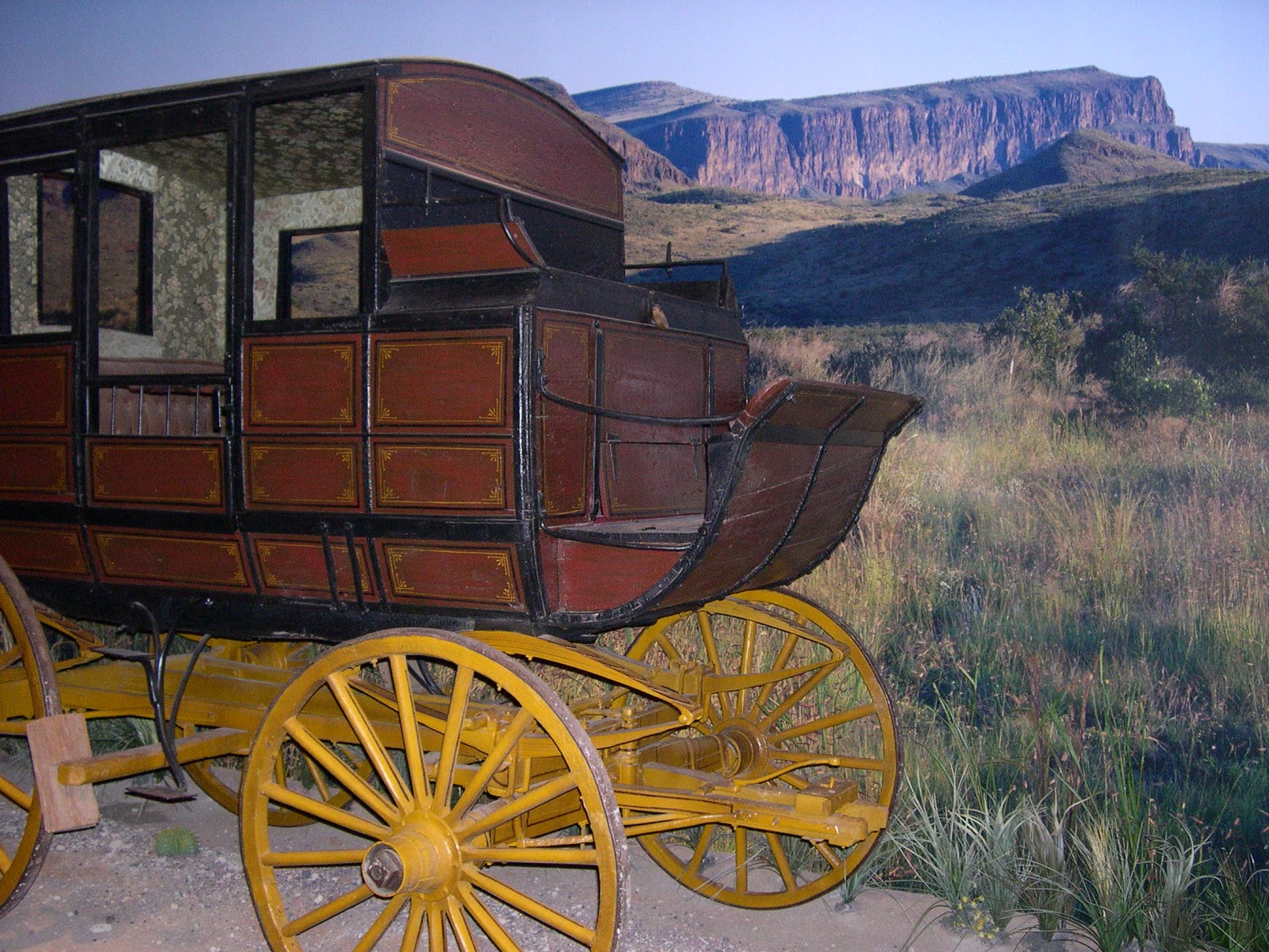
Van Horn's Clark Hotel Museum exhibits relics from earlier days in Culberson County, including this bonnet and carriage, donations from local residents.
 
All photos by Dan Baeza.  Dan also created the Museum's website during his internship last summer with our Texas Mountain Trail and the Clark Hotel Museum! 

Thursday, February 28, 2013

Wednesday, February 27, 2013

Lovelies from the Cactus Greenhouse

One of the brightest places to show color just about anytime of the year is the Cactus Greenhouse in Fort Davis' Chihuahuan Desert Nature Center and Botanical Gardens.
Though our skies are generally bright this time of year, we always feel cheered by what we see in the greenhouse.  Usually something's blooming there!


Tuesday, February 26, 2013

What You Hear at the Fort

When you visit the wonderful Fort Davis National Historic Site, you'll hear the bugle calls.  The bugle was used to signal to the soldiers as to the work of the day...from meal times, to work times, to school for the children at the fort, to lights out at night.  It takes almost no imagination to put yourself back to the 1870s and 1880s when the Fort was full of soldiers.

We wanted to share some of that experience with all of you, with the gracious help of the Fort Davis National Historic Site interpretive staff.

We've organized more videos to take you through a Morning at the Fort.  Click here to experience it!

Consider yourself invited to watch all our videos about the Texas Mountain Trail region!

Monday, February 25, 2013

Tacos!!

El Paso native and chef, Aaron Sanchez, talks about a local institution, Chico's Tacos, on "The Best Thing I Ever Ate!"

Sunday, February 24, 2013

New Word on the "Tiffany" Dome

Dome in El Paso's historic
El Camino Real hotel
Photo: THC
For some time, the stained glass dome in El Paso's historic El Camino Real hotel has been a "go to" site for visitors and residents of the city.  It graces the bar of the hotel beautifully.  Long called a "Tiffany" dome, there's been some speculation about its origin. 

Our Texas Mountain Trail board members from El Paso are dilgent in supporting the city's history, and knowing rumor and and they're terrific champions of the truth.  Turns out the "Tiffany" dome is really a Tiffany-style dome.

Thanks to TMT Board President Emeritus, Bernie Sargent, and Prince McKenzie of the Railroad and Transportation Museum of El Paso for scouting out the truth.  From Prince McKenzie:

"My mentor Dr. Clarke Garnsey, Prof. Emeritus, Art Dept. TWC/UTEP, was retained by Franklin Land to evaluate the dome, as they began the building restoration of the hotel. Having been trained at the Cleveland Art Institute, he knew what I D marks to look for and where, and he believed the dome to be designed by a Chicago studio and positively not Tiffany.

Later as a Curator at the Art Museum, I studied the various stained glass windows of the W. H. Turney Home and identified all the makers except one. I identified windows designed by Trost, and even had one restored. The big problem for me was the great Palladian stained glass window on the grand staircase of the Turney Home. I believed it to be the same maker as the dome of the Paso del Norte because of three factors; same period, same quality and same architect.

Now I believe you have found the answer. Garnsey told Franklin Land not to describe it as a Tiffany but stated that it was of equal quality. After the building was sold the new owners could not resist making the Tiffany claim in their advertising."

Saturday, February 23, 2013

Be a Part of El Paso History!!

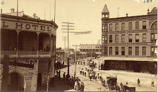
Downtown El Paso (Plaza in center back) around 1890s
Photo: Collection of the El Paso County Historical Society
Event: El Paso History Summit.
When: March 16, 2013
Time: Noon to 6 p.m.
Where: 1340 Murchison
Scenic View Ballroom of the First Presbyterian Church (near Brown St.) This free event is open to the public and is hosted by the El Paso History Radio Show, El Paso County Historical Commission, El Paso Mission Trail Association, and El Camino Real de Tierra Adentro Trail Association (CARTA). The El Paso History Summit is an opportunity for El Pasoans to help define what El Paso history is and how it should be preserved. Event organizers will use participants’ feedback to better promote heritage tourism for the Paso del Norte region.

Bring up to 10 photos that are at least 25 years old and have all persons identified, if possible, as well as the date and place. Photos are to be scanned onsite and returned back to the owners. The goal is to include all these photos on the interactive Digital Wall that will be installed at the El Paso Museum of History.

The summit will also kick off the “I Am El Paso” campaign, where the public can video record a 1-2 minute message that identifies themselves to the El Paso area. There will be a Town Hall meeting on El Paso history with special invited guests state Senator Jose Rodriguez and El Paso County Historical Commission chairman, Bernie Sargent. The Town Hall will be moderated by hosts of "The El Paso History Radio Show," Jackson Polk and Melissa Sargent.

Other events include screenings of local documentaries, such as, “El Paso’s Mission Trails” and the world premiere of segments from Capstone Productions’ latest documentary, "The Last Tour of theEl Paso Smelter." After three years of filming the demolition of the former Asarco site, the first installment of the El Paso Smelter documentary series covers the history and construction of one of the world’s tallest smokestacks.

Be a part of the first El Paso History Summit by sharing your history of El Paso with the community and help promote our diverse cultural identity. There will also be giveaways and other door prizes throughout the day.

Friday, February 22, 2013

Cloud Watchers

A hand in the clouds?
One of our Texas Mountain Trail board members in El Paso, Herb Price, has a great view of the sky above the Franklin Mountains from his home.  From time to time, he sends photos of El Paso's magnificent sunsets to share with all of you.  This time, he took a great photo of...what's that?  A hand pointing to the sky?  We take it as a reminder to spend a few moments every day to look at the sky and take in the beauty!

TRAVEL SPOTLIGHT!
Here's one of our cycle-friendly hotel properties to consider when you're heading to Big Bend, Big Bend Resorts and Adventures!  We stayed there during our recent trip to the Chihuahuan Desert Bike Fest, and yes, you can park your bikes in the room overnight!  The convenient location is 12 miles from Barton Warnock Environmental Education Center, 5 miles from Terlingua Ghost Town and a couple of miles from the western entrance to Big Bend National Park.

Thursday, February 21, 2013

Riding to McGuirk's Dream, Part 2

Mountain bikers were greeted
by TPWD's Linda Hedges
who interpreted the site
Yesterday, we started our report on our ride to the Contrabando Canyon's rock house ruin, the former home of H.W. McGuirk in the late 1890s.  We were there on a ride at the Chihuahuan Desert Bike Fest, a cooperative effort of TPWD, Big Bend Ranch State Park, Desert Sports, Big Bend Trails Alliance and many other dedicated volunteers.

We took one of the easier rides, an 11+ mile trek to the rock house.  When we arrived, TWPD's Linda Hedges told us all about the ruin, and guided us through an illuminating look at the site. 

Continuing our information from TPWD:

"The roof was constructed with wood timber framing (vigas of cottonwood) as rafters gathered on site, an ddesigned with a shallow pitech to shed water towards the canyon below.  Both the original section and the addition of small fireplaces for cooking, with very nicely constructed chimneys indicating that the work was undertaken by experienced craftsmen.

 
The rock house ruin's many rooms
shown here
 
Remnants of a corral in the foreground
Immediately adjacent to the residence is a series of small, ribbon-like stone fence enclosures, no more than 3 feet high, that were likely used to protect small livestock.


Wednesday, February 20, 2013

Riding to McGuirk's Dream, Part 1

TPWD's (and TMT board member) Linda Hedges
leads an interpretive hike to Casa Contrabando
during the Chihuahuan Desert Bike Fest
Recently, we participated in the Chihuahuan Desert Bike Fest down in Lajitas and Big Bend Ranch State Park.  We took the Festival's Contrabando Ride, 11+ miles in the state park, led by volunteers and knowledgable TPWD interpreters.  We headed north from Barton Warnock Environmental Education Center on Hwy 170, the River Road, up single and double-track trails into Big Bend Ranch State Park.  Halfway through our ride, we ended up at Contrabando Water Hole and the ruins of H.W. McGuirk's stone house from the late 1890s.

From TPWD:

"H.W. McGuirk began ranching in the area around 1885.  He expanded operations and moved his headquarters here to Contrabando Waterhole about 12 years later.   But water contamination in the spring, possibly poisoning, soon forced him to abandon this site and move to the Rio Grande, where he founded the community of Lajitas.

fireplace in the stone house ruin
Begun sometime during the late 1890s, the dwelling at Contrabando Waterhole began as a "patio"--a cleared area enclosed by a short, stacked stone wall.  The building was constructed within these defining perimeter walls, and consisted of 4 rooms built over the course of at least two building campaigns.  Both the original dwelling and the attached addition emply the same mazonry wall construction techniques, utilizing locally-collected native Boquillas flagstone in a random-laid patter, with a minimum of earth mortar used to stabilize the walls. 
 
There is evidence that, as the structure fell to ruin, efforts were made to reconstruct some of the walls using smaller rocks, tightly packed.  Though very little of the wood framing remains, one can see the location of the window and door openings."  
 
We loved visiting the Stone House ruin
on the Contrabando ride during the
Chihuhuan Desert Bike Fest.
Thanks to all, including Stonewear
Designs, for your rugged Echo Top!

Our BIG BIG thanks to all involved putting on the Festival, from TPWD and its staff from Big Bend Ranch State Park, Barton Warnock Environmental Education Center, and from across the state, Desert Sports, Big Bend Trail Alliance and many other dedicated volunteers and willing organizations.


Tuesday, February 19, 2013

When you say, "You'll go back in time," how far back is that?


Any traveler to the region will tell you:
 
We've got--
 
Wide Open Spaces
Freedom
Frontier
 
And not many people---
 
A lone participant in the Chihuahuan Desert Bike Fest
contemplates the ruins of a candellia factory in
Big Bend Ranch State Park

Our population density is VERY low.. the latest census in Brewster County (where Big Bend National Park, Terlingua, Alpine and Marathon are located) counted 1.49 people per square mile. 
 
In Presidio County (Marfa, Shafter and Presidio), there are 2.03 people per square mile. 
 
And in Jeff Davis County (Fort Davis and Valentine) there are 1.03 people per square mile.
 
And those numbers, by a simple measure used by the federal government (fewer than six people per square mile) is FRONTIER.
 
How long has it been since your hometown has been "frontier," or this sparsely populated?
 
So you live in Austin?  When was the last time Travis County had a comparable level of population density? Answer:  The earliest census numbers we could find were in 1850, and by that time, Travis County had 3.07 people per square mile.
 
Dallas? Dallas County had 1.75 people per square mile by 1860, the first census number we could find; and by 1870, it was 7.77 people per square mile.
 
San Antonio? Bexar County already had 4.81 people per square mile by 1850.
 
So when you're looking at landscapes like ours, you're looking at a time long before there were cars to take us around.  That's why we love events that put us out in the landscape, and why we think getting around by horse, by foot, or by bike gives you a better idea of what the "frontier" is all about.

Last weekend, riders in the Chihuahuan Desert Bike Fest were treated to "epic" rides in Big Bend Ranch State Park, and because of the involvement of many volunteers and TPWD interpretive staff, they learned quite a bit about our land and our history.

Participants in one of the Friday rides line up at
Barton Warnock Environmental Education Center
Riders on the Contrabando trail complex in
Big Bend Ranch State Park

Monday, February 18, 2013

Friday's sunset

Highway 90 West in Marfa
 
Early light of Friday's sunset from above a neighborhood
fence in Marfa

Sunday, February 17, 2013

Scenes from a GREAT Museum


One of the best small museums you'll find anywhere is in Alpine on the campus of Sul Ross State University, the Museum of the Big Bend.  The museum's staff, volunteers and donors have built a tremendous resource for visitors and residents of the area, for the museum illuminates and helps us understand our shared history.
 
From the Museum's website:

"The exhibit Big Bend Legacy greets visitors as they enter the Museum of the Big Bend. Legacy introduces visitors to the distinctive natural history, human history and confluence of cultures in the Big Bend region.
Native Americans inhabited the area for thousands of years before the arrival of the Europeans. The Spanish, through their system of missions and presidios, imprinted their customs on the region only to be replaced by the nation of Mexico. The westward expansion of the United States brought yet another unique culture to the Big Bend.
 
Many exhibits are enchanced
with video displays


Big Bend Legacy invites the visitor to experience this panorama of natural and human history.

Every year, the Museum hosts "Trappings of Texas" a terrific exhibition and sale of cowboy gear and Western art...the longest running event of its kind in the country.  Learn more here.

Travel Spotlight!


Members of our Texas Mountain Trail get a discount at the Museum of the Big Bend's gift shop!  Click here to become a member.

Saturday, February 16, 2013

Hiking to the Top of Texas, Guadalupe Peak by Sarah Clark

Sarah Clark is a Community Outreach SCA AmeriCorps Intern serving at Guadalupe Mountains National Park.  She's helping us promote the Peak Fitness Challenge, a free hiking challenge in Guadalupe Mountains National Park and Franklin Mountains State Park
 
 
Mountain tops seem to hold a special place in men’s minds. Moses came down from the mountain top with the moral code that has shaped the lives of millions of people for thousands of years. Native Americans seek their visions among the mountain tops, while Buddhist monks remain to find nirvana. The mountain top is a symbol of clarity, knowledge, and enlightenment. The effort and struggles of gaining the peak are integral to the significance of gaining the summit. No one would say they had conquered a mountain by flying to the top in a helicopter. No, each step on the way to the top has its own place and meaning.
The hike to the top of Guadalupe Peak is no different. As you work your way up the trail the desert floor falls away; the sounds of the highway gradually fade. Valleys and hills unfold before you, curving away to join ridge upon ridge, knitted together by rock and tree. Rounding a corner opens new worlds, as barren hillsides and sheer cliff faces become mountain slopes covered in pines, only to give way to the grassy shoulders of the peak. The air, thin enough to give pause as you switchback your way through the steepest sections of the trail, fills with the scent of pine. Even with your eyes closed, the air near the peak would tell you that you are far from the rest of the world. The last scramble to the summit, full of white fossil rich rocks of a long vanished reef, brings you face to face with the goal of your long climb. The mountain top is yours. Away below is the work-a-day world. But here, on the top, the press of everyday affairs is far away. Whether the first or the hundredth time to the top, the summit brings its own sense of time and scale to your perspective. As you gradually make your way back down the trail the headiness of the summit will remain. Distances seem changed, perspectives reframed. The memory of the view from the top is contrasted with where you are. Once returned to the base, the moments of clarity on the mountain top, with only the sky above you, the winds around you, and all the world below, remain.
Sarah Clark
 

Adventure Spotlight: JOIN the Peak Fitness Challenge!


This free, fun challenge is designed to entice you to try new parks and new trails and new challenges!  How does it work?
1) Sign up at www.geobetty.com/peak  (This is FREE!)
2) Browse the challenge site to find trails you'd like to try
3) Get out on the trail, complete your hike, and log it on your profile on the Peak Fitness Challenge website
4) Once you log a hike, your name is entered in a monthly drawing for
neat prizes!