Showing posts with label Presidio. Show all posts

Tuesday, October 07, 2014

Angi English Snaps Sauceda


Flickr found these amazing shots by Photographer Angi English of Big Bend Ranch State Park and the Sauceda Ranch House that you can rent out for the night. Awesome photos, Angi!


Monday, August 18, 2014

Colorado Canyon River Access

Colorado Canyon pull-off along Hwy 170, the scenic River Road, between Presidio and Lajitas is a favorite river access site, but is also a great place to pull off the road and enjoy the surroundings.

This section of the road runs through Big Bend Ranch State Park, which says this about Colorado Canyon:


"The Rio Grande/Rio Bravo corridor is an easily accessible area of the park for day use, including rafting, canoeing and free bank fishing. Several river access points are found within the park along F.M. 170. Colorado Canyon includes Class II and Class III rapids. This section of the river is not considered dangerous under normal flow conditions. The walls of Colorado Canyon, unlike the limestone canyons of Big Bend National Park and the Lower Canyons, are composed entirely of igneous rock. Raft trips may be arranged through local outfitters in Terlingua and Study Butte."

Information on river trips offered by area outfitters, here!

Thursday, March 20, 2014

Presidio BiNational Arts Festival Next Weekend!

Presidio, Texas Welcomes You to the Arts of the Big Bend of Texas!
The Presidio Arts Festival 2014 is inviting local artists, student artists, professional and amateur alike, dance groups, musicians, performers and cultural organizations to participate in the 3rd annual Presidio Arts Festival. This event will be an annual celebration that will be held this year on March 27,28,29, 2014.
One new event will be our own “Artwalk”… to Ojinaga, on Thursday, March 27th, where artists, dance groups, & vendors will perform and sell their wares. This event is the brainstorm of our own Mayor, John Ferguson. It will give our sister city a chance to shine and participate in our Bi National Arts Festival! You will be able to walk across and enjoy all of the activities!
- See more at: http://texasmountaintrail.com/events/presidio-binational-arts-festival#sthash.8tcQpvBh.dpuf

The Presidio Arts Festival 2014 is inviting local artists, student artists, professional and amateur alike, dance groups, musicians, performers and cultural organizations to participate in the 3rd annual Presidio Arts Festival, March 27-29!


Tuesday, March 18, 2014

Combating Nature Deficit Disorder in the Texas Mountains

One of the greatest assets of the Texas Mountain Trail region is our deep connection to nature.  Above is a profound video (12 minutes long) from a young woman who speaks eloquently about the need for experience with the natural world.

Where can you connect yourself (and your kids) to nature?

Try--
El Paso's Keystone Heritage Park, Franklin Mountains State Park, Museum of Archaeology, Wyler Aerial Tramway
Guadalupe Mountains National Park
Davis Mountains State Park
Chihuahuan Desert Nature Center just outside Fort Davis
Marathon's Post Park
Big Bend Ranch State Park
Lajitas' Barton Warnock Visitor Center
Presidio's Fort Leaton State Historic Site
Big Bend National Park (if you're interested in outfitters for a guided experience, click here.)
A happy participant at
Chihuahuan Desert Nature Center's
Toddle on the Wild Side
photo: Jessica Glasscock, CDRI

The book referenced in the video is Last Child in the Woods by Richard Louv.  Read about it here.

Also, visit our events calendar for experiences and opportunities in our parks and natural areas...more parks and attractions are posting their events with us...www.texasmountaintrail.com/events !!

Tuesday, February 18, 2014

Big Bend's Big Hill

River Road looking west over the Rio Grande
Possibly one of the most scenic spots along one of the most scenic highways in the state of Texas is the Big Hill on Hwy 170.  Connecting Terlingua/Study Butte to Presidio, Hwy 170, also known as the River Road is a highlight of any visit to Big Bend.

National Geographic says this about the River Road:

"From Shafter, drive to Presidio and pick up signs for the River Road (FM-170); the 67-mile (108-kilometer) stretch between Presidio and Study Butte offers photo-worthy scenery along the way. On your right are glimpses of the usually muddy Rio Grande, its banks half hidden by cane. Local resident Bill MacLeod, author of River Road Vistas, recommends the following: "Stop at the top of Big Hill overlooking the Santana Basin for the single best view in the whole world."

And our friends at Lajitas cite the road's status as one of the 50 most scenic in the country (by Readers Digest) and a Top 20 Bucket List item by Texas Monthly! 

There's a great place to stop at the top of Big Hill to see the scenic vistas, both east and west.   Read more about the River Road on the Lajitas website, here
River Road looking east
Plenty of room for travelers to stop at the top, park the car,
and get out and enjoy the view


Monday, February 17, 2014

Bluebonnets blooming along Big Bend's River Road!

Taken Saturday along Hwy 170 on the River Road, which connects Terlingua to Presidio by the Rio Grande.  So many stands of beautiful bluebonnets!  Some of the best on were around Lajitas this weekend!

Monday, October 28, 2013

Colorado Canyon, Along the River Road

Colorado Canyon pull-off along Hwy 170, the scenic River Road, between Presidio and Lajitas is a favorite river access site, but is also a great place to pull off the road and enjoy the surroundings.

This section of the road runs through Big Bend Ranch State Park, which says this about Colorado Canyon:

"The Rio Grande/Rio Bravo corridor is an easily accessible area of the park for day use, including rafting, canoeing and free bank fishing. Several river access points are found within the park along F.M. 170. Colorado Canyon includes Class II and Class III rapids. This section of the river is not considered dangerous under normal flow conditions. The walls of Colorado Canyon, unlike the limestone canyons of Big Bend National Park and the Lower Canyons, are composed entirely of igneous rock. Raft trips may be arranged through local outfitters in Terlingua and Study Butte."

Information on river trips offered by area outfitters, here!

Monday, July 15, 2013

Beautiful Fort Leaton

Fort Leaton State Historic Site, located just east of Presidio on the River Road, Hwy 170 is worth a stop to learn about the archaeology, history and natural history of the Rio Grande area.  Tour the beautiful adobe structure, view the exhibits, take a few moments to take shelter from the sun, as early travelers did.  This was a fortified trading post in the turbulent 1880s, yet key historical dates for the site reach back to 1848.

Download the interpretive guide for the site, here.

Dowload the self-guided tour booklet for the site, here.

Fort Leaton also serves as a park office and welcoming center for Big Bend Ranch State Park.  Permits for backpacking and camping (no hookups) at Big Bend Ranch State Park can be obtained at Fort Leaton or the Barton Warnock Visitor Center, on the eastern edge of the park near Lajitas. Visitors can also purchase river-use permits, licenses, and information about the Big Bend region.

Sunday, December 09, 2012

Las Posadas in Fort Davis last night

Click on any of the photos for a closer view! 
(Do you see the courthouse dome in the background?!?)

The procession leaving the Harvard hotel,
walking up the street to the Hotel Limpia.
Angels, shepherds, and kings alike enjoy cookies and cupcakes.
Last night, Fort Davis had their Las Posadas, a holiday-time procession through town, visiting hotel after hotel asking if the innkeepers would let Mary and Joseph in for the night.  A tradition popular in Mexico as well as our region, "Posadas" is Spanish for "lodging" or "accommodation." 

According to Wikipedia, "At each house, the resident responds by singing a song and Mary and Joseph are finally recognized and allowed to enter. Once the "innkeepers" let them in, the group of guests come into the home and kneel around the Nativity scene to pray. Latin American countries have continued to celebrate this holiday to this day, with very few changes to the tradition.

In some places, the final location may be a church instead of a home.


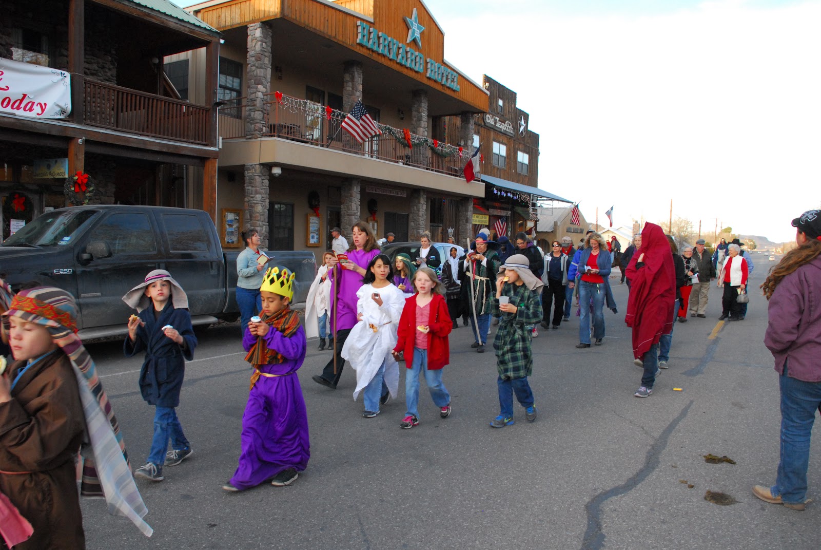
Individuals may actually play the various parts of Mary (María) and Joseph with the expectant mother riding a real donkey (burro), with attendants such as angels and shepherds acquired along the way, or the pilgrims may carry images of the holy personages instead.


The procession leaves Hotel Limpia
 Would you like to see and learn more about this tradition and Christmas in the borderlands?  Check out this video from Texas Parks and Wildlife about the Las Posadas at Fort Leaton near Presidio!


Saturday, December 08, 2012

Scenes from the River Road

Hwy 170 between Terlingua and Presidio offers some of the very best wilderness scenery anywhere.  From the edge of Big Bend National Park, through the southern boundary of Big Bend Ranch State Park and along the Rio Grande....enjoy the ride!
Hwy 170 is part of the historic driving route, the Texas
Mountain Trail designated to celebrate Texas in anticipation
of San Antonio hosting the World's Fair in 1968


Tuesday, November 27, 2012

A Trip to Candelaria, in Two Parts by Monte Riggs


Candelaria Texas, November 8, 2012
Knowing that there is no place to stop and eat or buy gas, I pack a sandwich, some carrots and trail mix, fill up the truck and head for Ranch Road 2810 which heads south at the Rock Shop on highway 90 west of downtown Marfa. Neither food nor fuel will be available until I get back to Marfa unless I head over to Presidio, but that’s 35 miles out of the way.
It’s a good day to be on the road in Presidio County Texas, the lovegrass, goosegrass, burrograss and grammagrasses, their families and friends are abundant and glowing in their best fall golden yellows and rust. A slight breeze blows out of the south arching their long stems to face me as roll by at 55 miles an hour. I pass a border patrolman parked on the side of the road and wave because I’m probably the first car he’s seen in a while and continue on. A solitary raven sits precariously atop a small fence post, it’s feet dwarfing the tiny perch of weathered wood. I see no other traffic on the road for the 32 miles to Pinto Canyon, this is why you learn to always consider the “what ifs” when you travel some of these back roads.
If you’re in no hurry, this drive is as beautiful as any in the country. Endless rolling pastures bearing scars from numerous geologic disturbances softened only by erosion and a healthy savannah which segue into the ruggedness of the Chinati Mountain range further south.
Thirty two miles south of Marfa the pavement stops and from here on to the Rio Grande the trip is over a gravel road that gets increasingly rough and challenging to the abilities of both car and driver. I shift into four wheel drive and slow down to keep the wake of dust behind me to a minimum. Besides, this road has enough blind corners where the unexpected can tear up your car in a heartbeat. Even in a high clearance four wheel drive truck a slow crawl is sometimes necessary.

Continued tomorrow!

Monday, August 13, 2012

Scenes from the River Road, Hwy 170 along the Rio Grande

Just east of Presidio, Fort Leaton State Historic Site

The southernmost loop of the historic 1960s driving route, from which our organization was formed, snakes by the Rio Grande from Presidio to Terlingua.  Hwy 170, known as the River Road was part of the grand plan by the State of Texas to introduce our great places to the world during HemisFair '68.  They put up highway signs for 10 looped driving "trails" throughout Texas to take travelers to places that are uniquely Texan.  So along with the Texas Forts Trail, Texas Plains Trail, Texas Forest Trail and so on, our Texas Mountain Trail was begun.

It wasn't until the late 1990s that our non-profits started developing, each a regionally-based, regionally-governed organization assisted by the Texas Historical Commission and charged with promoting heritage tourism.  Our Texas Mountain Trail was formed in 2005, and we've been promoting Far West Texas, supporting communities, and developing tourism products--like the Far West Texas Wildlife Trail (with TPWD), cycle-friendly programs and the new Peak Fitness Challenge.

We use this blog to introduce our special Far West Texas places to travelers, so you can plan trips to our region...trips that provide you with the kind of adventure YOU want.  Seeing it here on the blog is nice, but seeing it in person is terrific, right?  So next time you're in the region, plan to take in the beauty of the River Road.  It is one of the most scenic drives you'll find in the entire state! 

Thursday, July 12, 2012

Dawn Near the River Road

Taken at dawn in a stretch of Big Bend Ranch State Park along Hwy 170, the River Road next to the Rio Grande between Terlingua and Presidio!

Sunday, May 27, 2012

A cooler place on a hot day down by the river

For a short, easy hiking adventure with plenty of shade from the hot sun, try Closed Canyon in Big Bend Ranch State Park
Light reaches through the narrow Closed Canyon, part of Big Bend Ranch State Park
easily accessible from the River Road between Terlingua and Presidio

This is an easy, 1.4 mile hike in shade most of the time, and considered a highlight of any visit to Big Bend Ranch State Park. 

Hikers enjoy the stroll between tall rock canyon faces; this is a cool and quiet place just above the Rio Grande.  There are stretches with slick rock at your feet, and places with an abrupt drop of a yard or so....so only go as far into the canyon as you feel comfortable.  We'd recommend taking this hike on clear days, since a (rare) day with rain could produce a flash flood.

The trailhead is located on Hwy 170, known as the River Road, between the Ranchieras West and Ranchieras East trailheads.  After a brief hike through typical Chihuahuan Desert terrain, you reach the canyon opening.

Our friend, Dawn, wrote a wonderful blog entry (with lots of great pictures!) about her hike in the canyon.  Read it here.

Here's a link to a detailed trail report.

Thursday, May 10, 2012

Adobe Alliance


Images above: The Swan Home near Presidio and the entrance to Big Bend Ranch State Park
There's an interesting organization in our region dedicated to adobe and earth architecture.  The home shown in the photos is located near the entrance to Big Bend Ranch State Park, near Presidio.

The Adobe Alliance is a non-profit group dedicated to:
  • helping communities apply cooperative building techniques in earth architecture;
  • educate groups in fulfilling the widespread need for low cost, salubrious, energy efficient, sustainable housing; 
  • enhance rather than defile landscapes by designing solid contemporary structures of simple design which respect local climate, environment and culture.
purpose.jpg 
Means to reach these goals include:
  • the use of local renewable, recycled resources and building materials to considerably reduce cost and environmental impact, avoiding the use of industrial materials;
  • providing roofs in the configuration of adobe vaults and domes, a unique yet ancient design feature which eliminates the use of wood, an increasingly scarce natural resource;
  • designs which harness natural energy for heating and cooling . Adobe walls retain heat in the winter and stay cool in the summer, eliminating the cost of mechanical heating and cooling systems;
  • a system to meet local housing needs using indigenous skills, thereby providing a source of employment and simultaneously incorporating, preserving and enhancing local architectural heritage.
  • an appropriate building technique for chemically sensitive individuals, using only materials that are totally non-toxic. 
 Read more about this organization, programs and workshops here. 

The Adobe Alliance is a Texas based tax-exempt 501(c)3 corporation.

Tuesday, March 27, 2012

Beautiful sunrise

Taken along the River Road Hwy 170 between Presidio and Lajitas.  So pretty!

Saturday, March 03, 2012

Sagrado Corazon de Jesus, in Shafter

The beautiful church of Shafter, seen from Hwy 67 on the road from Marfa to Presidio.

Thursday, March 01, 2012

Views of the River Road

Hwy 170--the River Road--between Terlingua and Presidio, is part of the historic driving route set in the 1960s, the Texas Mountain Trail, upon which our organization was built to promote the heritage and great places you can visit in Far West Texas!
Rio Grande view from the River Road, Hwy 170
Colorado Canyon river access point from Hwy 170