Roadrunners are born to run! These birds move at speeds of up to 18 miles per hour, and they're excellent hunters. They can even catch and eat rattlesnakes! Get more info here >>http://bit.ly/11f2H5f Photo © Ralph Arvesen/flickr — with Graciana Imas.
Your daily photo of gorgeous Far West Texas featuring Big Bend National Park, the Davis Mountains, Guadalupe Mountains National Park, El Paso and all points in between!
Showing posts with label wildlife. Show all posts
Thursday, December 11, 2014
Wednesday, November 05, 2014
Nursing Pronghorn
Here's a Throwback Thursday of nursing Pronghorn. Gorgeous!

Friday, June 27, 2014
Javelina
First time visitors to the region are often delighted with a sighting of perhaps our wildest-looking animal in the Texas Mountains. We took this photo at the El Paso Zoo, but they live in most corners of the region..in the mountains, grasslands and ranches. Learn more about the javelina, here.
The Zoo features animals of the Americas, of Africa, and of Asia. It is a great place to visit, and the staff offers a terrific calendar of special events.
If you'd like to visit birding and wildlife viewing sites in the region, consult the Far West Texas Wildlife Trail, a cooperative effort between Texas Parks and Wildlife and our own Texas Mountain Trail organization.
The Zoo features animals of the Americas, of Africa, and of Asia. It is a great place to visit, and the staff offers a terrific calendar of special events.
If you'd like to visit birding and wildlife viewing sites in the region, consult the Far West Texas Wildlife Trail, a cooperative effort between Texas Parks and Wildlife and our own Texas Mountain Trail organization.
Sunday, July 14, 2013
Follow Us: We're on Instagram too!
There's a way you can see our "on our travels" photos...follow us on Instagram? We're @texastrailgirl and we try to show you instantly the highlights of all our stops in the Texas Mountains. This is a great way to see some of the dishes we order at regional restaurants, and some of our wildlife sightings! Below is a sunning pronghorn we saw on one of our bike rides outside Marfa:
Above is a delicious beef appetizer we ordered at the Blue Mountain Bistro in Fort Davis, next to the historic Limpia Hotel!
Labels:
food,
Fort Davis,
Hotel Limpia,
instagram,
Marfa,
wildlife
Tuesday, June 25, 2013
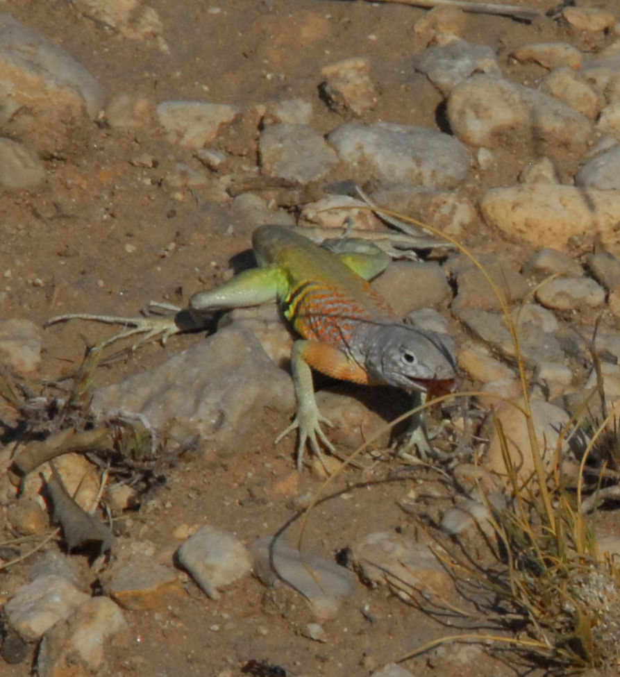
Greater Earless Lizard
This weekend, the Texas Mountain Trail, along with three chapters of Texas Master Naturalists (from El Paso, from Midland/Odessa and from the Davis Mtns/Big Bend) worked in Guadalupe Mountains National Park, learning from rangers, hiking the trails and developing a volunteer cadre to help the park during peak visitation times. Plans are afoot to invite more Texas Master Naturalists to lead interpretive hikes on the park's trails.
When heading back from our hike to Pratt Cabin on the McKittrick Canyon trail, we encountered this Greater Earless Lizard. We noticed him first because of his color and his quick movement along the trail. Then he'd stop running away from us, stop, and wait, perched on top of a large rock next to the trail. And then he'd do pushups! The movement is thought to signal territory and send a message, "get out of my space."
He repeated this sequence several times and we crept forward, trying to get photographs to share with all of you. We saw him along the trail near the end of our hike, in the rocky arid pathway not too far from the Visitors Center.
To learn more, here's a great page on the Greater Earless Lizard from Desert USA: http://www.desertusa.com/animals/greater-earless-lizard.html
Why do lizards do pushups? Here's an article by livescience.com: http://www.livescience.com/32192-why-do-lizards-do-push-ups.html
Head on out to the Guadalupe Mountains' McKittrick Canyon...perhaps you'll see a Greater Earless Lizard yourself!
McKittrick Canyon trail is one of the places marked on the Far West Texas Wildlife Trail, a project of our Texas Mountain Trail along with Texas Parks and Wildlife and our neighboring Texas Pecos Trail.
And the hike is one of our Texas Mountain Trail Heritage Hikes in the Peak Fitness Challenge!
When heading back from our hike to Pratt Cabin on the McKittrick Canyon trail, we encountered this Greater Earless Lizard. We noticed him first because of his color and his quick movement along the trail. Then he'd stop running away from us, stop, and wait, perched on top of a large rock next to the trail. And then he'd do pushups! The movement is thought to signal territory and send a message, "get out of my space."
He repeated this sequence several times and we crept forward, trying to get photographs to share with all of you. We saw him along the trail near the end of our hike, in the rocky arid pathway not too far from the Visitors Center.
To learn more, here's a great page on the Greater Earless Lizard from Desert USA: http://www.desertusa.com/animals/greater-earless-lizard.html
Why do lizards do pushups? Here's an article by livescience.com: http://www.livescience.com/32192-why-do-lizards-do-push-ups.html
Head on out to the Guadalupe Mountains' McKittrick Canyon...perhaps you'll see a Greater Earless Lizard yourself!
McKittrick Canyon trail is one of the places marked on the Far West Texas Wildlife Trail, a project of our Texas Mountain Trail along with Texas Parks and Wildlife and our neighboring Texas Pecos Trail.
And the hike is one of our Texas Mountain Trail Heritage Hikes in the Peak Fitness Challenge!
Monday, June 24, 2013
Guadalupe Columbine
| Guadalupe Columbine blooming along the creek in McKittrick Canyon Guadalupe Mountains National Park |
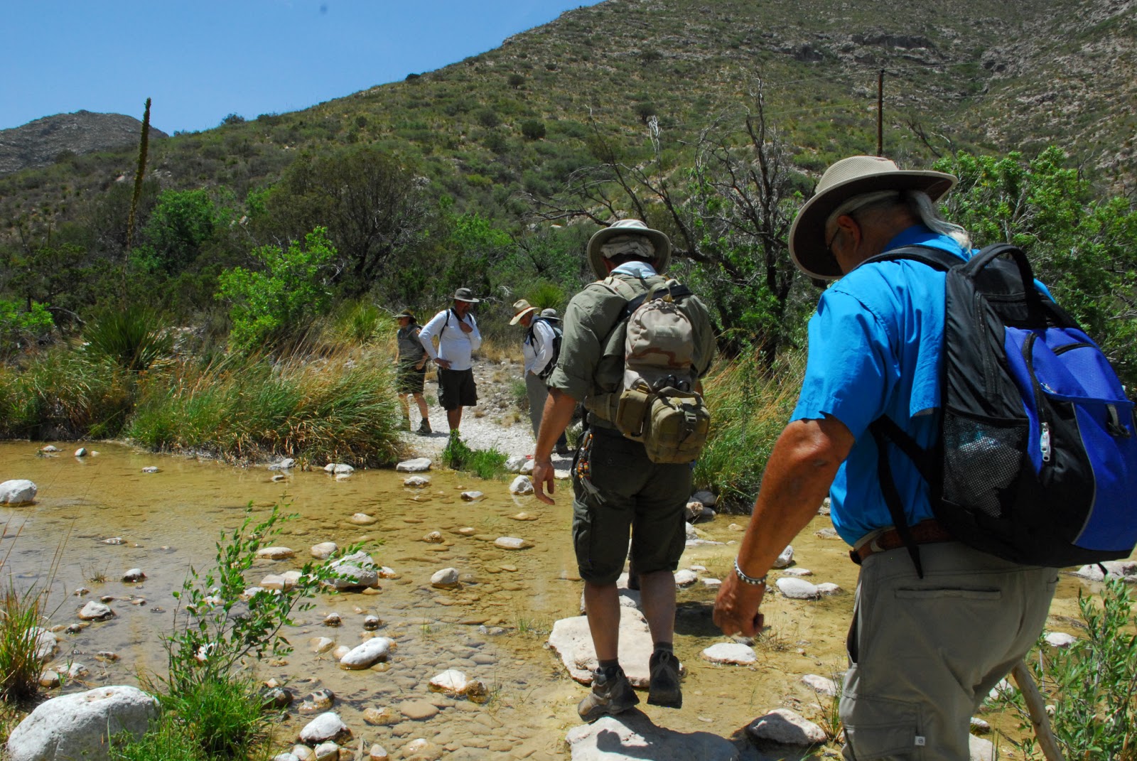
As part of the training we received from park staff, we hiked McKittrick Canyon on Saturday, sharing knowledge with each other along the way. While crossing the stream in McKittrick Canyon, we found this beauty, known as the Guadalupe Columbine.
| Our group crosses the stream in Guadalupe Mountains National Park McKittrick Canyon, shortly before we spotted the Guadalupe Columbine |
CHAPLINE COLUMBINE
Crowfoot Family
Ranunculaceae
"Aquilegia Chaplinei Indians cooked the roots of this attractive pale yellow flowered perennial herb and used them as a remedy for bruises; infrequent in shaded crevices, on boulders and calcareous soil of moist canyons, especially in North and South McKittrick Canyon of the Guadalupe Mountains National Park; April-November."
Steve West, in his book Northern Chihuahuan Desert Wildflowers, includes the flower with this additional information:
GUADALUPE COLUMBINE
Aquilegia chaplinei
Crowfoot Family (Ranunculaceae)
"Description: The plant grows up to 19" (48 cm) in height; the leaves are divided. Pale yellow flowers appear from April to November.
Habitat/Range: This columbine is one of the beautiful surprises you may encounter while hiking in the Guadalupe Mountains. Most often, it grows wherever there is permanent water, but it can also be found in moist places where water is not apparent. This species is easily found in McKittrick Canyon in the Guadalupes or in the adjacent Lincoln National Forest at Sitting Bull Falls, CCNP, GMNP.
Comments: Diversion of water from these sites could threaten this locally common species."
The McKittrick Canyon trail is on the Far West Texas Wildlife Trail and is part of the Peak Fitness Challenge (and one of our Texas Mountain Trail Heritage Hikes). Plan to visit Guadalupe Mountains National Park soon!
Sunday, May 26, 2013
Pronghorn babies
The drought has been hard on wildlife in the region, and the pronghorn populations appear to be affected. However, we DO see them out, and last night, we saw a mother and three babies along Hwy 17 between Fort Davis and Marfa!
| Click on the photos for a closer view! |
Thursday, May 16, 2013
Pronghorn
![]() |
| Photo courtesy of Texas Historical Commission |
![]() | ||
| Taken outside Marfa |
Labels:
Alpine,
Fort Davis,
Marfa,
pronghorn antelope,
Van Horn,
wildlife
Wednesday, April 24, 2013
Guadalupe Mountains National Park's Manzanita Springs
We're celebrating National Park Week, and you can too...free admission through April 28th! A place for birds and animals to gather, Manzanita Spring near Frijole Ranch in Guadalupe Mountains National Park. Click here to read more.
Labels:
birding,
Guadalupe Mountains National Park,
wildlife
Friday, April 05, 2013
Recruiting NOW, Texas Master Naturalists!
| Desert Bighorn Sheep taken at Elephant Mountain during Texas Master Naturalist training by Rich Gatchell Class of 2012 |
Now Accepting Applications! The Tierra Grande Chapter of the Texas Master Naturalist Program is accepting applications for its 2013 new member training program. Training this year will begin with a July evening “Kick Off” session in Alpine followed by four weekends starting in August and ending in October.
![]() |
| Mt. Livermore hike photo by Monte Riggs Class of 2012 |
Training weekends will be held at Davis Mountains Preserve, Chihuahuan Desert Research Institute, Balmorhea State Park, Elephant Mountain Wildlife Management Area and Big Bend Ranch State Park.
The Tierra Grande Chapter is a non-profit volunteer organization serving Brewster, Jeff Davis, Presidio counties and the greater Big Bend Region. Their mission is to develop a corps of well-educated master volunteers to provide education, outreach and service dedicated toward the beneficial management of natural resources within our communities.
| Desert Bighorn Sheep by Rich Gatchell |
Sandy Lynch
Training Committee
Tierra Grande Chapter, Texas Master Naturalists
Monday, March 18, 2013
Nest in Big Bend National Park
| It doesn't matter where you go, it pays to keep an eye out for a surprise or two |
Sunday, December 30, 2012
Wildlife at Chihuahuan Desert Nature Center...watch and enjoy!
| Here's a photograph of that same beetle |
Want to learn more? Here's a terrific TED Talks video about dung beetles, their behavior and how and why they roll balls of dung:
Now you can JOIN the non-profit Texas Mountain Trail and support our efforts to connect travelers with their own adventure in Far West Texas. Click here to join!
Tuesday, September 18, 2012
Right before sunset
![]() |
| Taken on Hwy 17 between Fort Davis and Marfa |
Monday, September 10, 2012
More Views of the Lost Mine Trail in Big Bend National Park
It was so pretty and green out on the Lost Mine Trail in Big Bend National Park on Friday afternoon, we had to show you more pictures! (Page down to see yesterday's entry too.)
Plan to visit the park soon!
Here's a link to the park's hiking page of mountain hikes, including the Lost Mine Trail!
Plan to visit the park soon!
Here's a link to the park's hiking page of mountain hikes, including the Lost Mine Trail!
Sunday, September 09, 2012
Look what we found on the Lost Mine Trail in Big Bend!
Friday afternoon, we hiked the Lost Mine Trail in Big Bend National Park...the entire Big Bend region is GREEN because we've had some nice rain. Come on out soon and see it for yourself!
Friday, September 07, 2012
Adventures in the Guadalupes, Hiking the El Capitan Trail
| Guadalupe Peak, the highest in Texas |
by
Andrew Stuart
Editor, Hudspeth County Herald and Dell Valley Review
Texas Mountain Trail Board Member
Editor, Hudspeth County Herald and Dell Valley Review
Texas Mountain Trail Board Member
The
trail passes from the grassy foothills of the eastern slopes to the stony
defiles below Capitan's tower, to the crest of the Salt Basin Overlook, at the
southern foot of El Capitan; from the overlook, the trail winds through sharp
and exposed terrain along the western face of the mountains, above vertiginous
heights and below the 2,000-foot cliffs of the escarpment, to the head of
Shumard Canyon. The path then drops down through the canyon's gorge to the
historic Williams Ranch House, built in 1908. On the return, the Salt Basin
Overlook Trail winds along the ledge below El Capitan, through a wonderland of
boulders. The trails can be taken as a shorter, 11.5-mile day hike, excluding
the leg from Shumard Canyon and back.
I carried, among other things, a sleeping bag, a tent, a light-weight camping
stove, some dishware and two gallons of water. A package of powdered,
just-add-water food. Early in the hike, feeling the weight of the water on my
back, it occurred to me it would be nice if someone would invent powdered
water. I guess, you know, you'd just add water.
| View from the east |
Around
the base of El Capitan, coming to the Salt Basin Overlook, and a sudden view of
much of Hudspeth County: the Patterson Hills, the flats and dunes, Round
Mountain – a little blemish on the flats, casting a tiny shadow; the Cornudas –
San Antonio, Chatfield, Wind mountains, Cerro Alto in the far distance, at the
El Paso County line; and, hazy in the southwest, Sierra Blanca, Little Blanca
and Round Top mountains.
I
spent a day and a half out in the wilderness, in the park, I sweated and
labored around boulder and cliff, with the broken rocks below and before me,
over pass and then pass again, circling, twisting about the colossus of El
Capitan. Oh, I sweated and labored, at home Sunday evening my shirt collar is
starched and blackened with sweat and dirt. I sweated and labored, and,
37-year-old that I am, no spring chicken, at one, or two, moments, I despaired:
on a gray helmet of rock, a beautiful place, overlooking the chasm of Shumard
Canyon, I saw the trail's end far below me – 1,000, 1,200 feet? – and balked at
the thought of having to retrace my path, back up the canyon, the next morning.
And again in the shaded slopes, the lea of the El Capitan Trail, on my return
journey, just past the junction of the Salt Basin Overlook trail, at the foot
my last serious climb. Now those points seem dear to me, especially the second,
the cool, blue place, where I thought perhaps I should just lay down and die.
From
the park's information:
“The
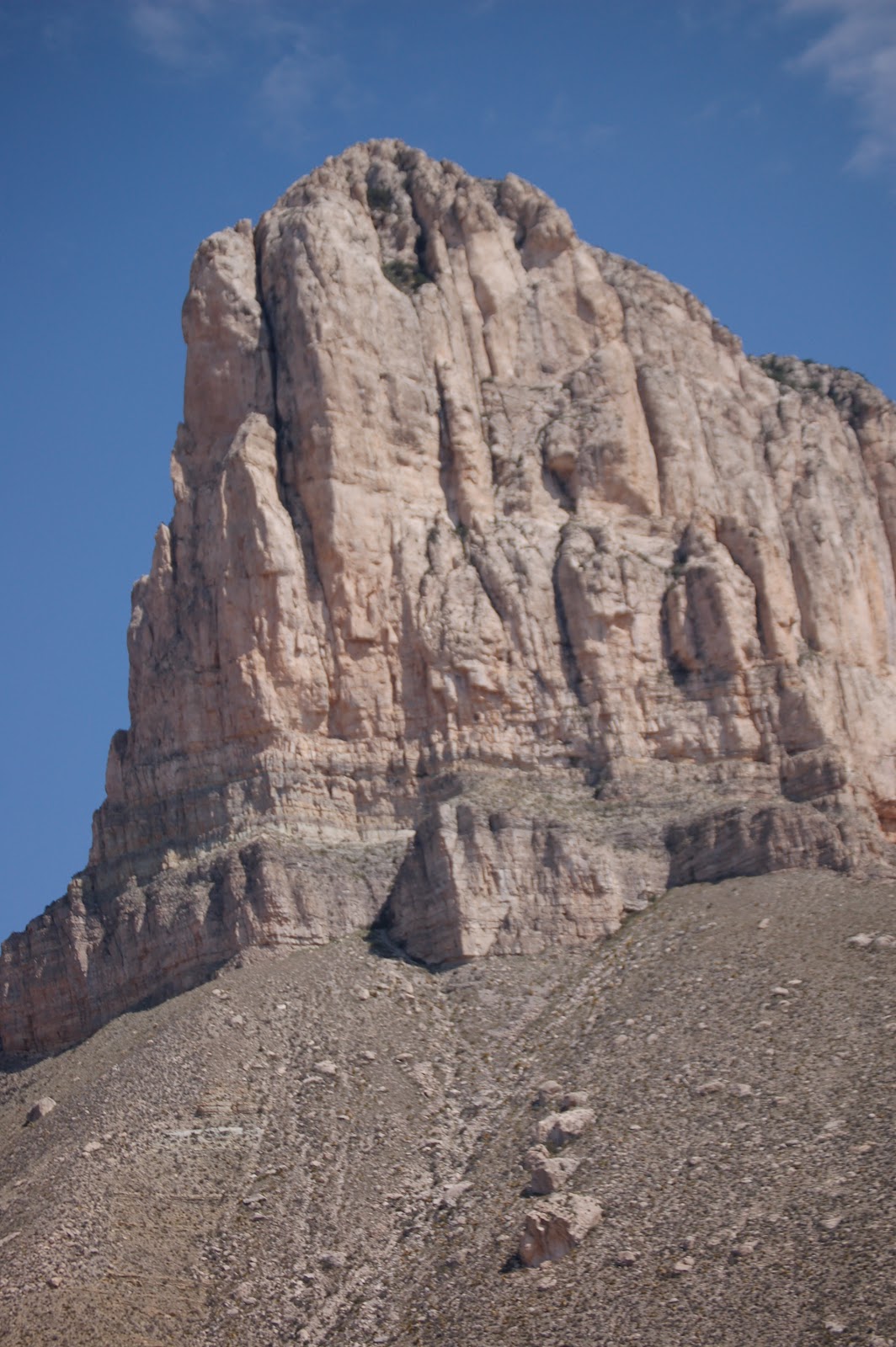
most striking feature of GuadalupeMountains National Park is the thousand-foot high El Capitan, which
can be seen from miles around. Early settlers used it as a landmark on the
route through Guadalupe Pass.
El Capitan is composed of Capitan Limestone, which is the
Permian-aged limestone reef deposit. A reef is a submerged resistant mound or
ridge formed by the accumulation of plant and animal skeletons. The Capitan
Limestone is a massive, fine-grained fossiliferous limestone that formed by
growth and accumulation of invertebrate skeleton of algae, sponges, and tiny
colonial animals called bryozoans. These skeletons were stabilized by
encrusting organisms that grew over and cemented the solid reef rock, unlike
modern reefs built by mainly a rigid framework of corals.
Below this massive cliff of Capitan Limestone you can see
a prominent sandstone ledge of the Brushy Canyon sandstone which formed when
the off-shore basin began to slowly subside.
| View from the West |
Because of the Capitan's greater resistance to erosion, it
forms this cliff which looms majestically above the horizon for us all to see.”
I
steered myself by that colossus. I gloried in it, at the overlook, its full
sentinel form above, wind sweeping east on the outward journey and west on the
return, or I despaired, when it was high above, above slopes strewn with
boulders, giant stones, from the age of titans. From the low points, the burned
desert, then again up, to within one mad scramble to the foot of the
escarpment. The honey-colored heights of the escarpment in mid-morning. I
walked across the charred ground where the El Capitan Fire burned, in May, and
saw the folds and that bare face of the mountain, which my neighbor and myself
see each day. I saw its dark places, its intimate folds. I cannot report, or I
can only report a part, of what I saw – its ugly secrets and its satin slipper,
its golden slumber.
The Salt Basin trail is part of the Peak Fitness Challenge, a project of the Texas Mountain Trail, GeoBetty, Guadalupe Mountains National Park and Franklin Mountains State Park. Here's the Challenge's page for the trail....join the Challenge today!
Thursday, September 06, 2012
Smith Spring Trail
by Drew Stuart
Editor, Hudspeth County Herald and Dell Valley ReviewTexas Mountain Trail Board Member|
Photos by Stephanie Smith
Editor, Hudspeth County Herald and Dell Valley ReviewTexas Mountain Trail Board Member|
Photos by Stephanie Smith
This is the third installment in a series on hikes in
Guadalupe Mountains National Park. The park celebrates its 40th
anniversary this year, and the Herald editor plans to hike all the park's
trails by the end of 2012 and to share something from each of the hikes with
Herald readers.
Sunday, Aug. 5, I made my third hike in three weeks in
Guadalupe Mountains National Park, to Smith Spring. I was joined on the hike by
Amy Muise of Crow Flat, her children Rhiannon and Emmett and Amy's sister, Stephanie
Smith. Stephanie was visiting and hoped to take a hike in the park – Amy
suggested Smith Spring, which was still on my list, as a good short hike. I
appreciated the company. Apart from McKittrick Canyon, which I expect to leave
for the fall, the trails that remain will be long treks – mostly into the high
country of the mountains – and it seems likely they'll be made alone.
A 2.3-mile loop, the Smith Spring Trail begins and ends at
the historic Frijole Ranch compound and, like other day hikes on the park's
east side, passes from grasslands marked by cacti and desert shrubs into wooded
canyons and limestone cliffs.
Determined to beat the heat, we planned a daybreak start for
our hike. I arrived at dawn, before my companions and in enough time to watch
the sun rise over the hills and flats to the northeast. Unlike the sunset
display Dell Citians and Salt Flatters can take in each afternoon – the two-,
three- or four-hour light show on the mountain's western escarpment – sunrise
on the other side of the mountain was a shorter and sharper affair – the sun
rose, and the limestone cliffs capping the mountains lit up briefly and
intensely, looking, for that moment, like a golden crown. I had some time to
walk around the old ranch house and splash cold water from Frijole Ranch Spring
on my face.
The group arrived, and we organized and hit the trail. At
Rhiannon's prompting, we reviewed how we would respond to an encounter with a
mountain lion or bear – always a good thing to consider – though the only the big
fauna we see are three mule deer, enjoying the ample forage of the slopes.
The ascent offers views of the bluffs and canyon above, a
dense jumble of white rock. It is a gentle and pleasant climb, and one broken
up, this day, by occasional breaks to sit down on the trail.
Near the spring, the trail passes into a clutch of woods, a
mini-forest. Rhiannon and I are in the lead, and as we enter the woods we hear
the thud of wings and watch a buzzard lift itself from a tree limb and fly down
the canyon. Then we catch the smell of something dead – confirming the claim of
the park's interpretive signage that Smith Spring is a “place of life and
death.” The trail crosses live water flowing over the rocks, and we come to the
springs themselves, draped with maidenhair fern and surrounded by oaks and
pines. A big madrone stands above the water, the red peels of its bark
scattered on the ground below, like piece of fancy stationary.
The rock of the Guadalupes is an ancient marine reef, formed
250 million years ago, when a vast inland sea covered much of what's now Texas
and New Mexico, geologists tell us. Rock made of algae, the skeletons of small
sea creatures and lime that precipitated from the ocean itself. The sea came
and went before mammals even existed; a dizzying thing to consider, however
much you've tried to think about geologic time. The stone formed hundreds of
millions of years before the volcanic activity that thrust up many of the other
mountains of Far West Texas and Southern New Mexico.
The limestone in the mountains is layered with other rock –
including sandstone, through which water can pass. Smith Spring – at 5,955
feet, one of the highest springs in Texas – flows from Bell Canyon sandstone;
rainfall in the mountains percolates through the joints in the sandstone and
limestone to emerge here and at the series of springs downhill.
Back down the trail, now on the north side of the canyon, to
the grasslands. Grass that, if not lush, would still gladden the heart of
ranchers on the other side of the mountain, Amy points out.
Nearing the ranch house, Smith Spring's water rises to the
surface again, at Manzanita Spring, surrounded by reeds and trees, including at
least one walnut. A sign here says that Manzanita and Smith springs and Frijole
Spring at the ranch house are among “five springs in a three-mile radius” – a
pretty remarkable concentration of water in this desert.
I sit on a picnic table back at the trailhead, with the
mountains behind me, chalky-looking mounds casting their cool white light as
the midday approaches. After the third walk in three weeks in the eastern
canyons and flanks of the Guadalupes, I feel the beginnings of a new comfort,
feel newly at home with this side of the mountains.
We eat lunch at a picnic table outside the ranch house,
where the heat is tempered by the presence of flowing water. Walking around the
ranch buildings, we meet up with a rattlesnake, just outside the ranch house
door – Rhiannon displays some impressive instincts and reflexes in jumping away
from the snake, which doesn't rattle. On our way out, we inform Eric, the park
muleskinner, about the snake, and he tells us he'd removed a snake from that
location recently – likely the same one. He can't blame the snake for coming
back, he says, as “this is the honeypot of the whole park,” which seems like a
good description for the wettest corner of the Guadalupes.
Our heartiest thanks to Drew and Stephanie! ---Texas Mountain TrailThe Smith Spring Trail is part of the Peak Fitness Challenge....sign up, hike the trail yourself and compete for prizes! The Peak Fitness Challenge is a cooperative program of Guadalupe Mountains National Park, Franklin Mountains State Park, GeoBetty.com and Texas Mountain Trail!
Sunday, September 02, 2012
How many do you see?
![]() |
| Click on the photo to get a closer view and count the turkey vultures! |
Want to learn more about this distinctive bird? Click here!
Sunday, August 05, 2012
Get Out of Here, Turkey!
![]() |
| These horses... |
![]() |
| chased this turkey right out of their ranchland pasture back into town, while.... |
![]() |
| turkey vultures sitting on fence posts watched the entire thing! |
Wednesday, July 18, 2012
Hummer Watching Season
![]() |
| Click on the images to get a closer view! |
Now's a GREAT time to watch hummingbirds who vie for space at feeders...where are some good places to view them? Try Chihuahuan Desert Nature Center, and Mountain Trails Lodge in Fort Davis, Dog Canyon Visitor Center in Guadalupe Mountains National Park. All are sites on the Far West Texas Wildlife Trail, a project of Texas Mountain Trail, TPWD, and Texas Pecos Trail!
Subscribe to:
Posts (Atom)


.jpg)
.jpg)
.jpg)
+(1).jpg)
.jpg)
.jpg)
.jpg)
.jpg)