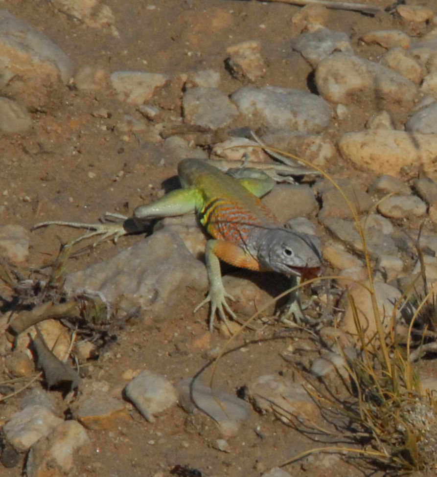
Your daily photo of gorgeous Far West Texas featuring Big Bend National Park, the Davis Mountains, Guadalupe Mountains National Park, El Paso and all points in between!
Showing posts with label Texas Master Naturalist. Show all posts
Friday, December 05, 2014
Thursday, December 04, 2014
Hiking on top of Texas
Here's a shot of some Master Naturalists hiking to the top of Mt. Livermore, located inside the Davis Mountains Preserve of the Texas Nature Conservancy.
Wednesday, July 02, 2014
A Million Dollars of Service
Tierra Grande Chapter of Texas Master Naturalist (serving the Big Bend/Davis Mountains area) celebrated a MAJOR milestone. This corps of trained volunteers dedicate service to parks, communities and non-profits to benefit our natural lands. And Saturday, the chapter celebrated that fact that since its formation in 2005, their members volunteered time equivalent of $1 million in support to the region!
The chapter works on trail building, area clean-ups, scientific studies, children's education programs, public hikes and adventures in our state and national parks, at our libraries, our natural lands.
Wednesday, May 21, 2014
Bird Blinds at Davis Mountains State Park
Davis Mountains State Park rangers and staff members, along with Texas Master Naturalists, recently completed this lovely bird blind structure on the main park road. Stop by in the morning and the evening to see an impressive array of birds! The new center has a water feature and several styles of bird feeders.
There are open air windows and glassed in windows to allow you to view the birds. Another alternative is the bird blind by the park's Interpretive Center, see below.
View from inside the Interpretive Center, where birds gather at a variety of feeders.
There are open air windows and glassed in windows to allow you to view the birds. Another alternative is the bird blind by the park's Interpretive Center, see below.
View from inside the Interpretive Center, where birds gather at a variety of feeders.
Tuesday, April 01, 2014
Do you want to be a Texas Master Naturalist?
Lunch atop Mount Livermore during a Texas Master Naturalist training weekend |
Now
Accepting Applications! The Tierra Grande Chapter of the Texas Master Naturalist
Program is accepting applications for its 2014 new member training program.
Training this year will begin with a June 28 “Kick Off” session in Marfa followed by four weekends starting in August and ending in October. Training weekends will be held at Davis Mountains Preserve, Davis Mountains State Park, Balmorhea State Park, Elephant Mountain Wildlife Management Area and Big Bend Ranch State Park.
The Tierra Grande Chapter is a non-profit volunteer organization serving Brewster, Jeff Davis, Presidio counties and the greater Big Bend Region. Their mission is to develop a corps of well-educated master volunteers to provide education, outreach and service dedicated toward the beneficial management of natural resources within our communities.
|
Application
deadline is May 15, 2014 with class size limited to 14 new members. For
applications and further information contact:
Sandy
Lynch
Secretary,
Training Committee Co-Chair
Tierra
Grande Chapter, Texas Master Naturalists
tierragrandetmn@gmail.com
#30DaysofBiking
We're participating in a fun challenge this April, that will deliver bikes to kids who don't have them. We'll also use this opportunity to showcase some of the great riding and cycling resources in our Texas Mountain Trail region of Far West Texas. What is this challenge? Here's a quote from the 30DaysofBiking website:
"You pledge to ride. We pledge to give. For every 30 folks who pledge to bike every day in April, we’ll give 1 bike to a kid in need via Free Bikes 4 Kidz.
At 30 Days of Biking, we’ve been growing a community of joyful cyclists since 2010. We encourage cyclists and non_cyclists alike to take a pledge to bike for 30 days. The pledge means a commute to work or an evening roll around the block. The pledge is also what binds us together as a community of cyclists. We’re all passionate about the bicycle and we know the bicycle can make us better people, build stronger communities and help a global environment.
So this year, we want to *create* more cyclists. When 30 people take the 30 Days of Biking pledge, we make more cyclists.
Our friends at Free Bikes 4 Kidz have donated 20,000 bicycles to kids in need since 2008. Those kids who receive a bike are kids who would not otherwise be able to afford one. Remember when you received your first bike and how happy you were? That’s what Free Bikes 4 Kidz does, and that’s what we can help them do more of. But first, we need you to pledge to bike every day in April.
Head to 30daysofbiking.com/pledge to join our community and help us pass along some bike love to another generation.
Happy pedaling!"
So stay tuned all month for updates on cycling in the Texas Mountains, and take the challenge yourself to enjoy your bike this April!
Sunday, March 09, 2014
Guided Hikes in Guadalupe Mountains National Park this Spring Break!
A cool place by Smith Spring in Guadalupe Mountains National Park |
Friday, January 24, 2014
Would you like to be a Texas Master Naturalist?
Our Big Bend/Davis Mountains chapter of Texas Master Naturalists, the Tierra Grande Chapter is holding a potluck and quarterly meeting Saturday, January 26th at Alpine's Kokernot Lodge from 1-4pm. This is a great chance to meet other members of the chapter and ask questions, find out what the chapter is planning to accomplish in 2014.
Tierra Grande is a fun group of folks interested in sharing their love of nature with others, providing outreach and education and volunteer support for nature-oriented projects in the region.
The potluck is listed on our Texas Mountain Trail events calendar, for details click HERE.
Tierra Grande is a fun group of folks interested in sharing their love of nature with others, providing outreach and education and volunteer support for nature-oriented projects in the region.
The potluck is listed on our Texas Mountain Trail events calendar, for details click HERE.
Thursday, October 31, 2013
Rock Art in Big Bend Ranch State Park
On a recent trip with the Tierra Grande Chapter of Texas Master Naturalists, we were treated to a ranger-led hike to see some rock art in a remote area of Big Bend Ranch State Park.
From the park's website:
"Big Bend Ranch State Park offers some of the most interesting archeology and history in the region. There are presently over 500 documented sites on the park. Many of the known sites are located near water sources but sites also occur on upland areas away from any obvious drainages, springs or tinajas. There is both need and potential at BBRSP for additional archaeological research to be conducted.
The earliest artifacts identified within BBRSP indicate that Native Americans traversed the area as early as perhaps 11,000 years ago, and continued to do so well into the 19th century. Native American site types attributable to the prehistoric era include open campsites, open camps associated with rock shelters, rock shelters, quarries, lithic scatters, Late Prehistoric Cielo complex (ca. A.D. 1250-1680) sites, rock art sites (primarily pictographs, or rock paintings) and special-use or ritual sites."
Interested in seeing rock art at the park? Our best recommendation is to contact a park ranger and schedule a ranger-led or outfitter-led outing.
Wednesday, October 30, 2013
Cinco Tinajas in Big Bend Ranch State Park
We recently took a hike in Big Bend Ranch State Park with the Tierra Grande Chapter of Texas Master Naturalists to Cinco Tinajas.
Some great information on this trail can be found in the park's El Solitario newsletter from 2007:
"Cinco Tinajas Trail is a short 30-minute stroll from Sauceda. The round-trip hike of less than 2 miles has an elevation change of less than 200 feet. At the end of the mile-long trail lies a close-up view of
the tinajas. And there’s more. The canyon rim overlooking the Cinco Tinajas provides incredible panoramas of the far reaches of the park. Tinajas are desert water basins carved in bedrock by the erosive force of sand, gravels, cobbles and larger stones suspended in rushing water. Many tinajas, including these, hold water even in the driest of times. Knowing the location of one of these natural water basins was, and is, knowledge that could save a person’s life.
Cinco Tinajas lies in a narrow slot canyon that contains a tributary of Leyva Creek. Almost all rain falling onto the upland area around Sauceda drains into this slot of dense volcanic rock, concentrating a powerful erosive force on a fault or crack in the lava. Over millions of years the erosion formed five (cinco) interconnecting pools."
Friday, June 28, 2013
Sunset in the Guadalupes
Our Texas Master Naturalist group of volunteers were honored to stay at Guadalupe Mountains National Park's research facility, the historic Ship on the Desert. The sunsets were spectacular from the roof of the second Guadalupe Mountains home of Wallace E. Pratt, which was built in the 1940s.
Thursday, June 27, 2013
Frijole Ranch
Training session at the orchard at Frijole Ranch in Guadalupe Mountains National Park |
Frijole Ranch is along the Smith Spring Trail, part of our Peak Fitness Challenge and a Texas Mountain Trail Heritage Hike. The Smith family operated their truck farming operation for nearly 40 years.
Read more about Frijole Ranch here. It is a great story of survival and perseverence.
Wednesday, June 26, 2013
Texas Master Naturalist Volunteers in Guadalupe Mountains National Park
Texas Master Naturalists headed to Guadalupe Mountains National Park to receive training, form partnerships and offer volunteer interpretive services. The group above represented the Llano Estacado Chapter from Midland/Odessa, the Trans Pecos Chapter from El Paso, and the Tierra Grande Chapter from Big Bend/Davis Mtns.
Watch for Texas Master Naturalist-led hikes at Guadalupe Mountains National Park during the fall color period, a direct outgrowth of this weekend's activities...brought to you by the dedicated Texas Master Naturalists volunteers and the Texas Mountain Trail!
The group received training from Ranger Michael Haynie at Frijole Ranch and the Smith Spring Trail |
McKittrick Canyon Trail |
Tuesday, June 25, 2013
Greater Earless Lizard
This weekend, the Texas Mountain Trail, along with three chapters of Texas Master Naturalists (from El Paso, from Midland/Odessa and from the Davis Mtns/Big Bend) worked in Guadalupe Mountains National Park, learning from rangers, hiking the trails and developing a volunteer cadre to help the park during peak visitation times. Plans are afoot to invite more Texas Master Naturalists to lead interpretive hikes on the park's trails.
When heading back from our hike to Pratt Cabin on the McKittrick Canyon trail, we encountered this Greater Earless Lizard. We noticed him first because of his color and his quick movement along the trail. Then he'd stop running away from us, stop, and wait, perched on top of a large rock next to the trail. And then he'd do pushups! The movement is thought to signal territory and send a message, "get out of my space."
He repeated this sequence several times and we crept forward, trying to get photographs to share with all of you. We saw him along the trail near the end of our hike, in the rocky arid pathway not too far from the Visitors Center.
To learn more, here's a great page on the Greater Earless Lizard from Desert USA: http://www.desertusa.com/animals/greater-earless-lizard.html
Why do lizards do pushups? Here's an article by livescience.com: http://www.livescience.com/32192-why-do-lizards-do-push-ups.html
Head on out to the Guadalupe Mountains' McKittrick Canyon...perhaps you'll see a Greater Earless Lizard yourself!
McKittrick Canyon trail is one of the places marked on the Far West Texas Wildlife Trail, a project of our Texas Mountain Trail along with Texas Parks and Wildlife and our neighboring Texas Pecos Trail.
And the hike is one of our Texas Mountain Trail Heritage Hikes in the Peak Fitness Challenge!
Monday, June 24, 2013
Guadalupe Columbine
Guadalupe Columbine blooming along the creek in McKittrick Canyon Guadalupe Mountains National Park |
As part of the training we received from park staff, we hiked McKittrick Canyon on Saturday, sharing knowledge with each other along the way. While crossing the stream in McKittrick Canyon, we found this beauty, known as the Guadalupe Columbine.
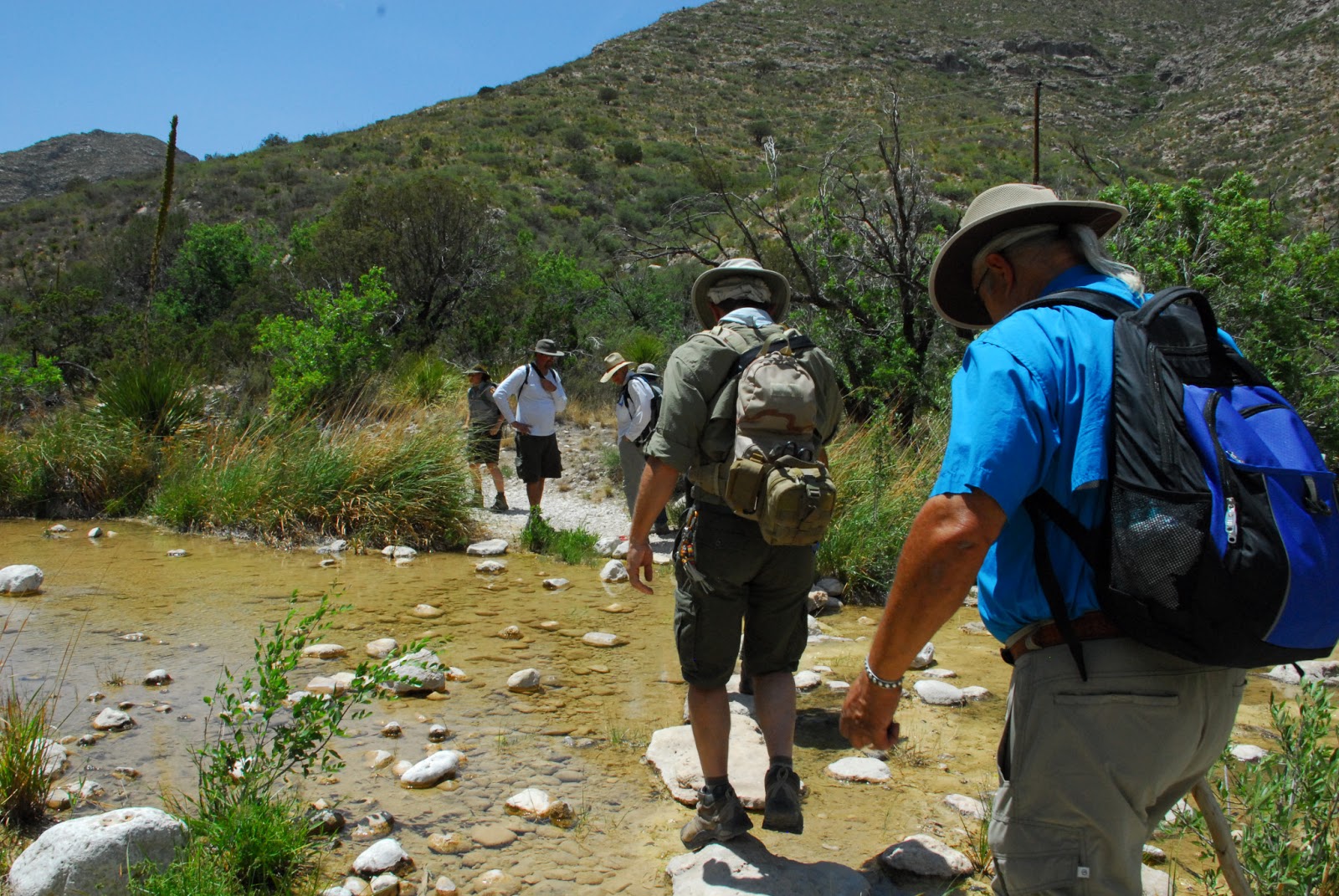
Our group crosses the stream in Guadalupe Mountains National Park McKittrick Canyon, shortly before we spotted the Guadalupe Columbine |
CHAPLINE COLUMBINE
Crowfoot Family
Ranunculaceae
"Aquilegia Chaplinei Indians cooked the roots of this attractive pale yellow flowered perennial herb and used them as a remedy for bruises; infrequent in shaded crevices, on boulders and calcareous soil of moist canyons, especially in North and South McKittrick Canyon of the Guadalupe Mountains National Park; April-November."
Steve West, in his book Northern Chihuahuan Desert Wildflowers, includes the flower with this additional information:
GUADALUPE COLUMBINE
Aquilegia chaplinei
Crowfoot Family (Ranunculaceae)
"Description: The plant grows up to 19" (48 cm) in height; the leaves are divided. Pale yellow flowers appear from April to November.
Habitat/Range: This columbine is one of the beautiful surprises you may encounter while hiking in the Guadalupe Mountains. Most often, it grows wherever there is permanent water, but it can also be found in moist places where water is not apparent. This species is easily found in McKittrick Canyon in the Guadalupes or in the adjacent Lincoln National Forest at Sitting Bull Falls, CCNP, GMNP.
Comments: Diversion of water from these sites could threaten this locally common species."
The McKittrick Canyon trail is on the Far West Texas Wildlife Trail and is part of the Peak Fitness Challenge (and one of our Texas Mountain Trail Heritage Hikes). Plan to visit Guadalupe Mountains National Park soon!
Wednesday, June 19, 2013
Hiking in the Guadalupe Mountains this Sunday with us!
![]() |
Cool shade of Smith Spring along the Smith Spring trail in Guadalupe Mountains National Park |
Trails are easy through moderate...and offer some of the best hiking in Guadalupe Mountains National Park:
Pinery Trail
Smith Spring Trail
Devils Hall Trail
McKittrick Canyon Trail
Most of the trails are Texas Mountain Trail Heritage Hikes...read more about that here!
Read more about the hike here, and join us on Sunday!
Direct link to our calendar listing for the hikes with all the information.
History Spotlight!
![]() |
William Travis poster by Kayla Acosta Click on the image for a closer view! |
When we visited the annual meeting of the Pecos-Mountain County Historical Commissions and heard about the great work the 7th graders at Fort Stockton Middle School, we wanted to share that great work with all of you!
![]() |
Nancy Hayter welcoming students to the Rollins-Sibley House and announcing Texas History Poster winners! |
Monday, June 10, 2013
Looking for a Great Sunday Outing? (on June 23rd!)
Pinery trail |
![]() |
Historic Frijole Ranch house on the Smith Spring Trail |
Devil's Hall trail in Guadalupe Mountains National Park |
You should carry your own water, wear sunscreen and clothing (including a hat!) that will protect you from the sun and desert plants. Choose the hike that best suits your fitness level, and have fun!
Here's the schedule for that day, and they're also listed on our Texas Mountain Trail events calendar:
8 am Pinery Trail, meet at the Pine Springs Visitors Center. This is a short paved trail of less than a mile to the historic stagecoach stop along the Butterfield Overland Trail. This trail is rated as EASY.
10 am Smith Spring trail, meet at the parking lot just before historic Frijole Ranch. This 2.6 miles loop trail takes you across desert and arroyos to a natural (shaded) spring. You also hike by Manzanita Spring and the Frijole Ranch house. This trail is rated MODERATE.
10 am McKittrick Canyon trail to Pratt Cabin This hike will take a few hours to hike the 5 mile roundtrip trail, but has a cool payoff (a rest on the porch of Pratt Cabin) at the endpoint before heading back to your car at the trailhead. What you'll see: maple, walnut, oak, and madrone grow alongside desert plants like cactus and agave. All are enclosed by steep walls that formed when the creek cut through the limestone of the Capitan Reef. Meet at the McKittrick Canyon trailhead building at 10 am. This trail is rated MODERATE.
10 am Devils Hall trail This is one of the prettiest hikes in the Guadalupes and is 2.2 miles one-way. At the farthest point you reach Devils Hall, a narrow notch in the mountain, offering shade! Meet at trailhead next to Pine Springs campground. This trail is rated MODERATE.
10 am Pinery Trail, repeat of the 8 am hike.
In the afternoon, Texas Master Naturalists will be at Frijole Ranch and eager to visit with all of you, and answer your questions!
If you encounter Texas Master Naturalists along the trail that day, please say hello!
How to participate in the Challenge? Start by creating a profile at the Peak Fitness Challenge website, here. You can choose any trail in Guadalupe Mountains National Park or Franklin Mountains State Park (El Paso) to hike or even run.
After you complete your hike, go back to the website to log your miles. Your name (and address) is put into a file from which we choose prize winners every month! The more you hike, the more chances you have to win prizes!
As an extra bonus, many of the hikes help us learn about our heritage. Click HERE to read about Texas Mountain Trail Heritage Hikes!
Big, big thanks to the three chapters of Texas Master Naturalists who are volunteering their time to lead hikes on Sunday, June 23! They come from El Paso, Midland/Odessa, and the Davis Mtns/Big Bend. Also we send thanks to our Peak Fitness Challenge partners, GeoBetty.com, PhiDev, Inc., Guadalupe Mountains National Park and Franklin Mountains State Park! Y'all are great!
Friday, June 07, 2013
Texas Master Naturalists leading Peak Fitness Challenge hikes in Guadalupe Mountains National Park
Ruins of the Butterfield Stagecoach stop on the Pinery Trail |
Sunday, June 23rd, Texas Master Naturalist volunteers from around Far West Texas are leading interpretive hikes in Guadalupe Mountains National Park as part of the Peak Fitness Challenge. Everyone is invited to choose the hike they'd like to do that day, and participate in the Challenge! This is something just about ANYONE can do! While you're responsible for the usual park admission fees, the hikes themselves are FREE!
You should carry your own water, wear sunscreen and clothing (including a hat!) that will protect you from the sun and desert plants. Choose the hike that best suits your fitness level, and have fun!
Here's the schedule for that day, and they're also listed on our Texas Mountain Trail events calendar:
8 am Pinery Trail, meet at the Pine Springs Visitors Center. This is a short paved trail of less than a mile to the historic stagecoach stop along the Butterfield Overland Trail. This trail is rated as EASY.
![]() |
The cool, shady portion of the Smith Spring trail |
10 am Smith Spring trail, meet at the parking lot just before historic Frijole Ranch. This 2.6 miles loop trail takes you across desert and arroyos to a natural (shaded) spring. You also hike by Manzanita Spring and the Frijole Ranch house. This trail is rated MODERATE.
McKittrick Canyon trail |
10 am McKittrick Canyon trail to Pratt Cabin This hike will take a few hours to hike the 5 mile roundtrip trail, but has a cool payoff (a rest on the porch of Pratt Cabin) at the endpoint before heading back to your car at the trailhead. What you'll see: maple, walnut, oak, and madrone grow alongside desert plants like cactus and agave. All are enclosed by steep walls that formed when the creek cut through the limestone of the Capitan Reef. Meet at the McKittrick Canyon trailhead building at 10 am. This trail is rated MODERATE.
![]() |
Devil's Hall trail |
10 am Devils Hall trail This is one of the prettiest hikes in the Guadalupes and is 2.2 miles one-way. At the farthest point you reach Devils Hall, a narrow notch in the mountain, offering shade! Meet at trailhead next to Pine Springs campground. This trail is rated MODERATE.
10 am Pinery Trail, repeat of the 8 am hike.
In the afternoon, Texas Master Naturalists will be at Frijole Ranch and eager to visit with all of you, and answer your questions!
If you encounter Texas Master Naturalists along the trail that day, please say hello!
How to participate in the Challenge? Start by creating a profile at the Peak Fitness Challenge website, here. You can choose any trail in Guadalupe Mountains National Park or Franklin Mountains State Park (El Paso) to hike or even run.
After you complete your hike, go back to the website to log your miles. Your name (and address) is put into a file from which we choose prize winners every month! The more you hike, the more chances you have to win prizes!
As an extra bonus, many of the hikes help us learn about our heritage. Click HERE to read about Texas Mountain Trail Heritage Hikes!
Big, big thanks to the three chapters of Texas Master Naturalists who are volunteering their time to lead hikes on Sunday, June 23! They come from El Paso, Midland/Odessa, and the Davis Mtns/Big Bend. Also we send thanks to our Peak Fitness Challenge partners, GeoBetty.com, PhiDev, Inc., Guadalupe Mountains National Park and Franklin Mountains State Park! Y'all are great!
Subscribe to:
Posts (Atom)