
Saturday, July 31, 2010
Daniel Baeza's Landscapes, Day 3
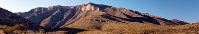
Friday, July 30, 2010
Daniel Baeza Week: Day 2

Another lovely panorama landscape from Van Horn native, Daniel Baeza. We're featuring his work all week; come back and see all his images of Far West Texas!
Thursday, July 29, 2010
Landscapes of Far West Texas by Daniel Baeza
We invite you to take a look at Daniel's photography blog: http://ulyssesbaeza.blogspot.com/
Wednesday, July 28, 2010

Tuesday, July 27, 2010

Monday, July 26, 2010
Big Bend Hoodoos!

Hoodoos (also sometimes called tent rocks or fairy chimneys) are spires of rock protruding from an arid drainage basin or badland. They're formed where soft sedimentary rock is topped by harder, less easily-eroded stone, protecting each column from the elements.
This neat shot was taken by Chuck Nowland, in July 2010...thanks, Chuck!
Sunday, July 25, 2010
Sunset over the Sierra Diablos

Taken north of Van Horn on Hwy 54 along the El Cap to El Cap heritage bike ride and the road to Guadalupe Mountains National Park!
Saturday, July 24, 2010
More Scenes from the Hummingbird and Butterfly Trail


Just outside Fort Davis is the Chihuahuan Desert Nature Center and its Hummingbird and Butterfly Trail--which is beautiful this time of year!
Friday, July 23, 2010
Scenes from the Hummingbird and Butterfly Trail


Visit this beautiful place yourself, at the Chihuahuan Desert Nature Center of Fort Davis--the Hummingbird and Butterfly Trail! The trail is just a third of a mile, but it offers so much beauty, especially this time of year!
Thursday, July 22, 2010
Summer Rain brings Green!

Plentiful summer rain turns the desert into a green oasis. This lovely ocotillo lives at the Chihuahuan Desert Nature Center and Botanical Gardens in Fort Davis near their Hummingbird and Butterfly Trail!
Wednesday, July 21, 2010
National Border Patrol Museum in El Paso

To learn more, visit their website!
The Museum is located next to the El Paso Museum of Archaeology on Transmountain Road...making it easy to visit both great places on the same trip!
Thanks to Randy Mallory and the Texas Historical Museum for this photograph!
Tuesday, July 20, 2010
Pronghorn Antelope

Monday, July 19, 2010
Motoring the Texas Mountain Trail

Sunday, July 18, 2010
Shafter Cemetery

Thanks to Randy Mallory and the Texas Historical Commission for use of this photo!
Saturday, July 17, 2010
El Paso Museum of Archaeology

The Museum tells the story of the first inhabitants of the El Paso area, the greater Southwest and northern Mexico. Exhibits like this one, reveal Native American lives from Paleoindian hunters of the Ice Age to their modern Indian descendants. The museum grounds include nature trails with native plant gardens and outdoor exhibits, and is next door to the National Border Patrol Museum.
Thanks to Randy Mallory and the Texas Historical Commission for use of this photo!
Friday, July 16, 2010
River Trips in Big Bend

One of the favorite adventures open to Big Bend visitors is a river trip. With the summer rains, the river is often READY for river-runners this time of year. The National Park has a comprehensive webpage with links to pages with outfitter contacts and important safety information.
We like to recommend two places to Big Bend visitors: Museum of the Big Bend in Alpine and Barton Warnock Environmental Education Center on the River Road. Combined, they give you a great introduction to the region: history, culture, and natural history.
Thanks to Randy Mallory and the Texas Historical Commission for this photo!
Thursday, July 15, 2010
The Road to Rio Grande Village, Big Bend National Park

Wednesday, July 14, 2010
Let's Go! Adventure on Pinto Canyon Road

The paved portion of the road is the location of two events this fall, the Marfa 100 bike ride (a Metric Century) and the Blackwell School Races.
Please note that on long stretches of the drive, the road cuts through private property and your travels should be restricted to the road only. Detours onto private land are not permitted by the landowners, so stay on the main road, stay in the car and enjoy the bumpy drive!
Thanks to Randy Mallory and the Texas Historical Commission for the use of this photograph!
Tuesday, July 13, 2010
Bunk at Fort Davis National Historic Site

Monday, July 12, 2010
River Road by Big Bend Ranch State Park

A lovely shot of the River Road (FM-170) by Randy Mallory for the Texas Historical Commission. Routinely named one of the most scenic drives in the state, the River Road connects Presidio to Terlingua and Big Bend National Park. For much of the route, the road bisects Big Bend Ranch State Park.
Sunday, July 11, 2010
Mitre Peak Peeking Out

A neat view of Mitre Peak along Hwy 118 between Fort Davis and Alpine taken by Larry Francell. Thanks, Larry!
Saturday, July 10, 2010
Taking the Train: Union Passenger Station, El Paso


El Paso's Union Passenger Station on the edge of downtown (pictured here) dates back to 1904, with a lovely restoration completed in 1982. Bright, airy, and clean, this is a beautiful structure inside and out.
Also in the neighborhood is El Paso's Railroad and Transportation Museum. To learn more, click here.
Friday, July 09, 2010

Thursday, July 08, 2010
Chamizal National Memorial, El Paso, TX. Mural and boundary markers.


 From the National Park Service website,
"In 1966, Congress established Chamizal National Memorial to commemorate the Chamizal Convention (treaty) of 1963. The Chamizal treaty finally ended a long-standing border dispute between the U.S. and Mexico. The 1848 Treaty of Guadalupe-Hidalgo established the Rio Grande/Río Bravo as the international boundary between the U.S. and Mexico. However, rivers naturally move over time. In this case, the river gradually, and at times abruptly, moved south, which left Mexico with less land than the 1848 treaty established. The land disputes that arose because of the river movement caused tension between the U.S. and Mexico for more than 100-years. Finally, in 1963 U.S. President John F. Kennedy and Mexican President Adolfo Lopez Mateos met to discuss the "Chamizal Issue” and through diplomatic negotiations, they solved the Chamizal Issue with the signing of the Chamizal Treaty.
The Memorial provides visitors with an opportunity to better understand the culture of our borderland."
Wednesday, July 07, 2010
Scenic Drive, El Paso


Routinely voted one of the best places to take visitors to show them El Paso, Scenic Drive!
The historical marker at Scenic Drive in El Paso says, "As early as 1881, El Paso leaders promoted the idea of creating a place at the base of the Franklin Mountains to provide visitors a panoramic view of the area. The automobile brought attention to the idea and in 1920 the City Council and Mayor Charles Davis approved construction of a scenic drive. Finished in October 1920, the route became a popular atraction. The 1.82 mile drive reaches an elevation of 4,222 feet, 500 feet above the Rio Grande. In 1932, the City contracted to widen and pave the road, and in 1934, Civilian Conservation Corps Company 855 (Fort Bliss) carried out additional culvert work. Scenic Drive continues to attract visitors to the view of El Paso, Cuidad Juarez, and the surrounding Chihuahuan Desert."
Tuesday, July 06, 2010
Get off the Freeway: the Green Oasis of Memorial Park


Monday, July 05, 2010
Get off the Freeway: Manhattan Heights neighborhood in El Paso, the Rose Garden


Just a few miles off I-10 is a lovely oasis, the El Paso Municipal Rose Garden, at 3418 Aurora at the edge of the historic Manhattan Heights neighborhood. The garden spans over 4 acres, has a waterfall, a koi pond, and walking paths. It is open all summer on the weekends. Get off the freeway and enjoy!
Sunday, July 04, 2010
Getting off the Freeway: Manhattan Heights in El Paso


 One of the sights you'll see when you explore the Manhattan Heights neighborhood of El Paso, is this lovingly restored gas station from 1919. Located at the corner of Grant and Elm, this beauty was the project of Canutillo antique dealer, Rod Davenport.
The Manhattan Heights neighborhood is here. To read more about the neighborhood's history, click here.
Saturday, July 03, 2010
Getting off I-10: Manhattan Heights neighborhood in El Paso
Most travelers never get off the freeway, and that's their loss. They miss places like the Manhattan Heights neighborhood of El Paso, which we'll feature in the next few days. Built in the shadow of the Franklin Mountains, this neighborhood has an historic beginning.
The city's website says this: "From 1901 to 1908, the Federal Copper Company operated a smelter on a barren stretch of land several miles northeast of downtown near the Franklin Mountains. After the smelter closed, the land was purchased and later platted as the Castle Heights and Manhattan Heights additions. The first named streets in the area reflected the land’s recent use—Federal, Bronze, Copper, Silver, and Gold. Local architect Otto H. Thorman designed a Georgian Revival influenced residence for Mr. and Mrs. S. H. Levell at 3037 Federal in 1914, which was the first home in new subdivision. Residential construction continued at a steady pace, and many of the first homes were spacious, well proportioned, and designed with Classical Revival and Georgian Revival stylistic influences."
Page down to read more!


Also from the city's website: "To the west of Memorial Park throughout the 1920s and 1930s, architects such as William G. Wuehrmann, Mabel Welch, and Henry Trost designed numerous residences. Each architect acknowledged the particular quality of El Paso’s Chihuahuan Desert environment and the region’s long-entrenched cultural connection to Spain and Mexico when designing homes from clients. As a result, many residences in Manhattan Heights contain Spanish Colonial Revival elements. The neighborhood also features numerous bungalows, the most prevalent single-family building type in the United States in the opening decades of the Twentieth Century, which contributes to the neighborhood’s visually richness. Welch championed Spanish Colonial Revival as the preferred and most appropriate architectural style for El Paso, and her work ably demonstrates her commitment to a respectful awareness of the community’s Hispanic heritage."
This is one of El Paso's most walkable neighborhoods, and we suggest, also one of the most bikeable. In fact, our cycle-friendly hotel, the Hyatt Place El Paso Airport will shuttle their guests and bikes across the freeway to within spitting distance of this lovely neighborhood. A map showing the neighborhood's location is here. Get out and look around!
Friday, July 02, 2010
Soccoro Mission on the El Paso Valley Mission Trail

From the Mission Trail website: "The Rio Grande played havoc on the locations of this charming mission. It took its name from Socorro of the North (New Mexico). The Piro Indians fled this area after the Pueblo Revolt of 1860 and established their new home. Sixty Piro families along with fifteen Spanish families dedicated the mission to Nuestra Senora de Limpia Concepcion de los Piros de Socorro del Sur (Our Lady of the Immaculate Conception of the Piros of Socorro of the South)."
"In 2005 the mission completed a 10 year restoration that showcases some original cypress roof supports called vigas (beams) that are were decorated by the Piro Indians."
You can read more about the Mission Trail here and here.
Thursday, July 01, 2010
Hummingbird Trail and Pollinator Garden


Fort Davis' Chihuahuan Desert Nature Center and Botanical Gardens has many features to enjoy--including hiking trails, gardens, cactus greenhouse, historical mining exhibit. These photos were taken in the pollinator garden and along the hummingbird trail (with the tip of Mitre Peak showing in the background)...when visiting Fort Davis, plan a trip to this wonderful place!
For information on hiking in Far West Texas, visit: www.texasmountaintrail.com/hike
For information on birding in Far West Texas, visit: www.texasmountaintrail.com/bird
Subscribe to:
Posts (Atom)