This little strip of road looks unremarkable, but it is historic with a capital H. Located on the grounds of Fort Davis National Historic Site, this is a remnant of the old San Antonio-El Paso road, a stagecoach route.
The Fort's website says this:
" In October 1855, Second Lieutenant Zenas R. Bliss, Eighth U. S.
Infantry, arrived at Fort Davis seventeen days after boarding the
westbound stage in San Antonio. "The Post was the most beautifully
situated of any that I have ever seen. It was in a narrow canyon with
perpendicular sides, the walls of which were about 200 feet in height,"
the young officer later wrote. The necessity for the post, located some
400 miles from San Antonio and 200 miles from Franklin (present-day El
Paso), stemmed from demands for protection on the San Antonio-El Paso
Road. A major link along the most southern route to California, the road
experienced an upsurge of travel in the early 1850s following the
discovery of gold in California. As travel along the road increased, so
did Comanche, Kiowa, and Apache raids into Mexico. Emigrants, mail
carriers and merchants journeyed in constant fear of the raiding
warriors who traveled between Mexico and their homelands to the north.
Despite its picturesque terrain, the buildings were uncomfortable and
difficult to keep warm. "I remember once in a snow storm the snow blew under my bed . . . and it stayed there several days without melting,"
wrote Lieutenant Bliss. In 1856, six stone barracks with thatched roofs
and flagstone floors replaced inadequate enlisted men’s quarters. Along
with the bakery, blacksmith shop, and a warehouse, they were the only
substantial structures of the first fort."
And this:
"The first Fort Davis served as a retreat for thousands of emigrants,
freighters, and travelers during the decade preceding the Civil War. It
provided protection for the U. S. Mail and saw the establishment of a
number of stage stations and military posts in the region, including
Fort Stockton and Fort Quitman. It was also an influencing factor in
1859 for the Butterfield Overland Mail to change its route to El Paso.
The new route came through Fort Davis instead of following the road
through the Guadalupe Mountains. Although the post did little to reduce
Indian activity in western Texas, its presence encouraged travel on the
San Antonio-El Paso Road and settlement in the Trans-Pecos region."
Straight off the Fort property to the east on "Fort Street" is the Overland Trail Museum, a community museum showing early life in Jeff Davis County. Definitely worth a stop, visitors not only enjoy the museum's exhibits but the fact that it is along the still unpaved, original San Antonio-El Paso Road.
You can read more about the first Fort Davis (1854-1862) and its history here.http://www.nps.gov/foda/historyculture/firstfortdavis.htm
Your daily photo of gorgeous Far West Texas featuring Big Bend National Park, the Davis Mountains, Guadalupe Mountains National Park, El Paso and all points in between!
Tuesday, May 15, 2012
Monday, May 14, 2012
Horses as Landscape
We are doubly pleased to share this lovely image with you once again, because the photographer, Dan Baeza, a Van Horn native and Texas A&M-Commerce student is doing a two week photography internship with us starting today! We've featured Dan's work twice now on this blog, and we're big fans of his work! We're so pleased to have him working on projects to benefit our Texas Mountain Trail and Van Horn's Clark Hotel Museum. Welcome Dan!
Sunday, May 13, 2012
Scenes from a GREAT DAY! Magoffin Home Reopens!
| The Casa Magoffin Comparneros were in attendance. This group supports the program of the Magoffin Home and raises funds for many projects, including several aspects of the renovation. |
| A Magoffin family member address the crowd. Several members of the Magoffin family attended the event. |
| Cliff Seaman plays his original song about El Paso's historic Concordia Cemetery, with Patricia Kiddney (grand dame of El Paso's reenactors and champion of Concordia Cemetery) listens in |
![]() |
| Sara Belger and Herb Price represented the El Paso Historical Society (Herb is also one of our Texas Mountain Trail Board Members!) |
| Musicians played in front of the Magoffin Home before and after the ribbon cutting |
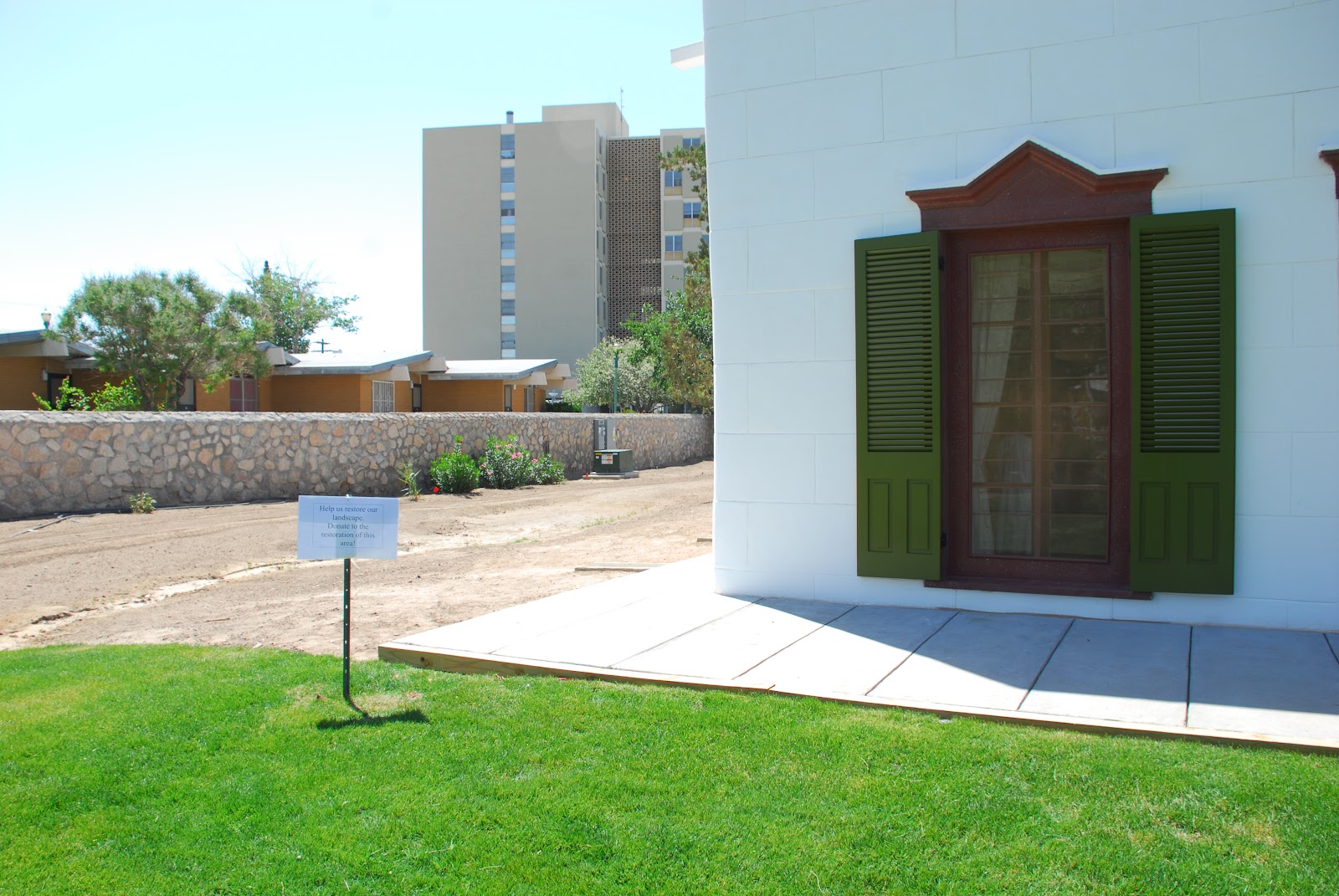
The Texas Historical Commission, which now administers the site, was responsible for the renovation work as well. Careful attention was paid to the special historic nature of the 1877 home, from authentic handpainted window treatments, to replacing the roof, to extensive work to the grounds.
Would you like to help? The sign above says, "Help us restore our landscape. Donate to the restoration of this area." One way you can do that is to join the Casa Magoffin Companeros, the Friends Group for the Home. Founded in 1992, this non-profit organization encourages volunteers to help at the home, "hosts fundraising events, and accepts and maintains donations, endowments and grants." To learn more click here. To join, contact them at: Casa Magoffin Companeros, 1120 Magoffin Ave., El Paso, TX 79901
Saturday, May 12, 2012
Magoffin Home Reopens Today!
| The front door of the Magoffin Home |
| Washing the dust off the windows and shutters, getting ready for the grand reopening today |
| Inside the courtyard of the Magoffin Home yesterday |
Want to learn more about the Magoffin Home? Here's a quote from the Texas Historical Commission's historic sites website:
"Born in Chihuahua, Mexico and educated in Kentucky and Missouri, Joseph Magoffin (1837–1923) first came to the El Paso area in 1856 to work in his father’s mercantile shop at Magoffinsville. After service in the U.S. Civil War, he returned with his family and became an advocate for the development of El Paso and the region. Using his extensive landholdings, he helped bring railroads, utilities and new businesses to town, increasing his personal fortune. He was a co-founder of the State National Bank, where he served as vice president for 40 years. He also served as county judge, four terms as mayor, collector of customs and in numerous other public offices. His wife Octavia (1845–1906) was a social leader in the community and active in Catholic charities. They had two children, Jim (J.W.) Magoffin (1864–1913) and Josephine (Josie) Magoffin Glasgow (1873–1968).
When Joseph and Octavia Magoffin moved into their new home in 1877, El Paso was a small frontier town. Joseph built the home on property he had obtained from his late father. The adobe construction reflects typical Spanish and Territorial architecture found in the Southwest borderlands and the influence of the Greek Revival style popular in other parts of the United States. In 1887, the El Paso Times described the homestead, “The grounds surrounding it comprise twenty acres, embraced in lawns, flower gardens, fruit orchards, vegetable beds, grass plats and small grain divisions.” The couple was well known for their hospitality and entertained guests frequently in the home."
The Texas Historical Commission acquired the Magoffin Home a few years ago, and has been administering and caring for the site since then. Come on out today and take a look for yourself!
Friday, May 11, 2012
Thursday, May 10, 2012
Adobe Alliance
![]() |
| Images above: The Swan Home near Presidio and the entrance to Big Bend Ranch State Park |
There's
an interesting organization in our region dedicated to adobe and earth
architecture. The home shown in the photos is located near the entrance
to Big Bend Ranch State Park, near Presidio.
The Adobe Alliance is a non-profit group dedicated to:
- helping communities apply cooperative building techniques in earth architecture;
- educate groups in fulfilling the widespread need for low cost, salubrious, energy efficient, sustainable housing;
- enhance rather than defile landscapes by designing solid contemporary structures of simple design which respect local climate, environment and culture.
Means to reach these goals include:
- the use of local renewable, recycled resources and building materials to considerably reduce cost and environmental impact, avoiding the use of industrial materials;
- providing roofs in the configuration of adobe vaults and domes, a unique yet ancient design feature which eliminates the use of wood, an increasingly scarce natural resource;
- designs which harness natural energy for heating and cooling . Adobe walls retain heat in the winter and stay cool in the summer, eliminating the cost of mechanical heating and cooling systems;
- a system to meet local housing needs using indigenous skills, thereby providing a source of employment and simultaneously incorporating, preserving and enhancing local architectural heritage.
- an appropriate building technique for chemically sensitive individuals, using only materials that are totally non-toxic.
Read more about this organization, programs and workshops here.
Labels:
adobe,
architecture,
Big Bend Ranch State Park,
Presidio
Wednesday, May 09, 2012
New "El Paso's Hueco Tanks" Video!
There's an excellent new video about Hueco Tanks State Park and Historic Site available for those with an interest in native peoples, rock art, the Butterfield Overland Mail Stage route, geology, birding, and on and on. The preview video is right here!
You can purchase a copy of the full video here.
Our Texas Mountain Trail board had a hand in the funding of this project, as we recommended it receive a grant from the Texas Historical Commission's heritage tourism partnership grant program.
(Sadly this grant program was discontinued due to state budget consideration.)
Tuesday, May 08, 2012
Celebrating our 1,500th Post!
![]() |
| Texas Mountain Trail sign marking part of the original 1960s driving route by David Lee Leggett (www.davidleggett.com) |
| Our photograph of Marfa's Presidio County Courthouse |
![]() |
| Our photo of Day of the Dead festivities in El Paso |
![]() |
| Van Horn native, Dan Baeza captures a lovely image (www.danbaeza.com) |
![]() |
| From a series on Six Man Football in West Texas, Sierra Blanca's team By Rob Hann (www.robhann.com) |
![]() |
| Fort Davis photographer, Carolyn Nored Miller Nursing pronghorn fauns (click on photo for a closer view) |
![]() |
| Fort Davis photographer, S. Billingsley (http://www.facebook.com/pages/Photo-By-S-Billingsley/270945169604890) |
![]() |
| Alpine's Chris Ruggia's Jack Comics (www.jackcomics.com) Click on the comic for a closer view! |
| Austin's Rob Hodges captures one of El Paso's murals (www.robhodges.com) |
![]() |
| Ocotillo captured by Derrick Birdsall (http://mysightpicture.wordpress.com) |
![]() |
| Kristin Muntean at Big Bend National Park's Ernst Tinaja (http://www.hazelwestphotography.com) |
![]() |
| Two hikers at Santa Elena Canyon in Big Bend National Park by Clara Maverick Riggs (http://www.facebook.com/claramaverickphotography) |
![]() |
| Big Bend Ranch Rodeo by David Lee Leggett (www.davidleggette.com) |
![]() |
| A historical image from early Van Horn from the collection of the Clark Hotel Museum |
![]() | ||
| Tiffany Dome in the El Camino Real hotel in El Paso by Randy Mallory for the Texas Historical Commission |
| Our photograph of Fort Leaton near Presidio |
| ||
| Red-tailed Hawk by El Pasoan Dennis McElveen (damfoto at sbcglobal dot net) |
Monday, May 07, 2012
Early Van Horn
Judging by similar photographs, we believe this photograph was taken after 1902. Note the adobe building going up in the foreground? And the wagons and the clothes in the line? Click on the photo for a closer view!
Sunday, May 06, 2012
The Only Adobe Courthouse in Texas
![]() | |
| The majestic entrance to the Hudspeth County Courthouse in Sierra Blanca Photo: Randy Mallory, THC |
From the Texas Historical Commission website:
"This 1919 building is the only adobe courthouse in Texas. Architects Buetell and Hardie designed the building in a Mediterranean style reminiscent of Renaissance Revival. Exterior work included installing new piers for structural reinforcing of the foundation to support the 18-inch adobe walls. A new metal shingle roof was installed and exterior stucco removed and replaced. Upgrades to mechanical, electrical and plumbing, as well as installation of an elevator and fully accessible bathrooms were incorporated. Work began in late 2002 and was completed by April 2004."
You can see photos of the restoration here and here.
:You can read more about Hudspeth County here.
Saturday, May 05, 2012
Drive through a Volcano!
| Hwy 90 between Alpine and Marfa, the way most people see it but what travelers may not realize they're passing through a rich geological history! |
![]() |
| Now with QR code-linked roadside exhibits, travelers can read the sign AND view online resources (websites, videos, etc.) right on the spot! |
Just yesterday, five miles from Alpine at the rest stop along Hwy 90, an impressive new roadside exhibit was dedicated. Stop there, get out your smartphone and in addition to reading about the geological history of this mountain pass, you can see video and view websites about it too!
Want to read the exhibit panel RIGHT NOW? See the Visit Big Bend History Snapshot web site here:
So what happened here? What about the volcano?
The blog of the Geological Society of America outlines the geological history of the Paisano Pass area:
"The development of the Paisano Volcano (abridged): 35 million years ago basaltic lavas erupted from a pluton approximately 5 miles in diameter that rose slowly from deep within the mantle and lodged into the crust approximately 2 to 3 miles below the surface. Explosive pyroclastic eruptions driven by steam and carbon dioxide ensued, followed by subsequent lava flows. After a quiet period, pyroclastic flows again began to erupt, and a caldera crater collapsed during violent explosions that partially emptied a magma chamber under the volcano. Finally, more lavas erupted, followed by late mafic dikes and plugs and much younger nepheline syenite intrusions into the older volcanic strata. Development of the broad shield complex was completed in 1 to 2 million years. Weathering and erosion continue to carve the different types of igneous rock into the colorful cliffs and wide valleys that seen around Paisano Pass today."
Want to see what the eruptions, collapses, and flows might have appeared? The beauty of combining QR codes into the exhibit allows visitors to see online resources about the area, including cool video! Click here to watch this video, which not only introduces the exhibit concept, but has great footage of volcanic activity.
The Brewster County Historical Commission assisted in the development of
historical information signs placed along the 400 plus miles of
highways in Brewster County. Each historical sign is approximately 3
feet by 5 feet in size with display information including maps,
photographs, diagrams text that describe the facts of the related
subjects which include geology, biology, archaeology and history.
This
is a joint project conducted with financial support provided from the
Brewster County Tourism Council, hotel/motel tax. An
agreement exists between Brewster County and Texas Department of Transportation for the placement of
these signs within the county highway right-of-ways. The selected
locations are at existing traffic turnouts, roadside parks or at a
position of access for tourists and educators traveling through the
area.
A
total of approximately 35 site locations will ultimately form a
historical marker route through Brewster County with a road log to be
prepared for the public and available on the Internet. These signs are
in addition to the traditional existing Texas Historical Commission
markers.
And the Geological Society of America Blog feature on the volcano exhibit here:
Installation of The Visit Big Bend History Snapshot Paisano Pass Volcano Exhibit On Highway 90.
More than thirty
representatives of Brewster County, The City of Alpine, Sul Ross State
University, Museum of the Big Bend, Bryan Wildenthal Library Archives,
and friends of the Visit Big Bend History Snapshot Project gathered
Friday morning at the Highway 90 Rest Area 5 miles west of downtown
Alpine, to celebrate the installation of exhibit number 6 of 35
projected roadside panels: The Paisano Pass Drive Through Volcano.
This project is
fortunate to have the support of many institutions and people, both
local and far flung, in the production of these interpretive exhibits
for the Visit Big Bend History Snapshot Project.
These include The
Museum of the Big Bend, The Bryan Wildenthal Archives, The Center for
Big Bend Studies, and The Science and History Departments of Sul Ross
State University. In addition the University of Texas Jackson School of
Earth Sciences and leading professionals from many other Texas
institutions have provided invaluable information, historical
photographs, and expert scientific and historical advice and review for
these exhibits.
First presented by
invitation during the March, 2012 Geological Society of America Regional
Conference hosted at Sul Ross State University, by Dr. Kevin Urbanczyk
and Dr. James Witford-Stark, this roadside attraction features an
entirely novel approach to outdoor education using the new QR Quick
Response Code, to link smartphone viewers directly to the Visit Big Bend
Web site.
This exhibit is
currently featured on the GSA Blog Site and on Youtube. The response
from across the country has been exceptional. So far Visit Big Bend is
the only entity using this technology for outdoor education and traveler
interpretation of the geology, biology and history of a Texas county.
Rondell Sanders is President of the Brewster County Tourism Council. Mike
Davidson, Alpine City Councilman, is Visit Big Bend Project Director.
Jim Bones is project photographer, and information compiler. Chris
Ruggia of Vast Graphics is principal exhibit designer.
Friday, May 04, 2012
Wildlife Trail and Cycling Routes Intertwine!
![]() | |||
| A lone cyclists enjoys the road from Marathon to Post Park, just off Adventure Cycling Association's Southern Tier Route, and part of the Alpine-Marathon Loop of the Far West Texas Wildlife Trail |
We also enjoy helping cyclists ride through our region, and have valued our work with Adventure Cycling Association, since their Southern Tier Route stretches through our region, from Marathon to El Paso. It was a terrific surprise to get an email from our friend, Jennifer Milyko, Adventure Cycling's cartographer recently. She'd received an email from a cyclist recommending they profile the Far West Texas Wildlife Trails on their blog, and we were more than happy to fill in the blanks! Here's Jenn's blog entry on the Adventure Cycling Association's blog, "Far West Texas and the Southern Tier."
Thursday, May 03, 2012
Dennis McElveen's Big Bend Week
One of the benefits of staying overnight in the Chisos Basin
in Big Bend National Park--at the Lodge or the
campground—is the stunning view of the setting sun through the Window.
We thank our guest photographer, Dennis McElveen, who’s
shared his beautiful images with us all week.
Dennis captured this lovely shot, “ The sunset view was taken from the
sunset vista near the visitors center in the Chisos Mountains
area. We were hoping for a colorful evening with the light bouncing off clouds
but this image popped from the clouds. The colorful sunset never appeared
because of the distant storm we didn't realize was coming later in the night.”
Big, big Texas Mountain Trail thanks to Dennis for his
generosity in sharing all these beautiful images of Big
Bend. Interested in
seeing more of Dennis’ work? Contact him
at damfoto (at) sbcglobal (dot) net
Wednesday, May 02, 2012
Desert and Mountain in Big Bend
Big Bend National Park has been called three parks in
one: river, desert, mountain, and here
our guest photographer, Dennis McElveen captures two of the three!
Dennis talks about this
photograph: “Shot this image of the Chisos Mountain Range just off the
trail that leads to the Windows Pour Off. The Windows is to the left out of
view. The ocotillos were blooming all over the park. The trail head that lead
to this view is the Oak Springs Trail.”
Our heartiest thanks to El Pasoan,
Dennis McElveen for sharing images from his recent trip to Big Bend National Park
with us all week. Interested in
seeing more of Dennis’ work? Contact him
at damfoto (at) sbcglobal (dot) net
Tuesday, May 01, 2012
Lost Mine Trail Views by Dennis McElveen
Our guest photographer, Dennis McElveen shares, “We were
actually the first people up the Lost Mine trail, at the crack of dawn. It was
quiet, peaceful and all so beautiful. Once we got to the top we lingered for
quite a while, picnicking and toasting the awesome views. Everyone for a while
wandered off, looking, shooting and just taking in the scenery.”
Big Bend National Park’s website offers this about this great trail, a
favorite of many:
Lost Mine Trail
Difficulty: Moderate; Distance: 4.8 miles round trip
Begin at mile 5.1 on the Basin Road, limited parking
Difficulty: Moderate; Distance: 4.8 miles round trip
Begin at mile 5.1 on the Basin Road, limited parking
This trail
serves as an outstanding introduction the flora and fauna of the Chisos Mountains.
With limited time, hike to marker 10 (about 1 mile), where a saddle offers
stunning views of Casa Grande and Juniper
Canyon. The remainder of
the trail climbs steeply in and out of juniper, oak, and pine forest. The
trail abruptly levels out at the ridge with superb views of Pine Canyon
and the Sierra del Carmen in Mexico.
A brochure is available at the trailhead.
Interested in other regional hiking opportunities? Visit our Texas Mountain Trail hiking
page: www.texasmountaintrail.com/hike
We thank Dennis McElveen for sharing his wonderful images
this week. Interested in seeing more of
Dennis’ work? Contact him at damfoto
(at) sbcglobal (dot) net
Subscribe to:
Posts (Atom)